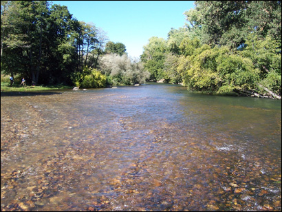
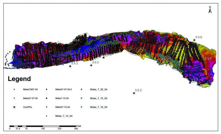
LMR 2004 Site
LMR 2004 Preliminary Planning
This was the second stage of a 2-stage project. In 2003, the riffle immediately below Camanche Dam had its crest elevation raised 1.5' and a new riffle slope was created starting at this elevation. In 2004, the goal was to raise the next riffle crest downstream (1999-site) sufficiently to achieve 2 objectives:
(1) "soft- land" velocity and depth at the 2003-riffle site as planned to yield the final desirable depth and velocity physical habitat conditions.
(2) transfer usable slope from the 2003-site riffle exit to the 1999-site riffle to increase velocity and depth there. The expectation was that the 1999 site would end up with somewhat excessive velocities that in turn could be "soft landed" by building up the riffle crest of the next downstream riffle below the 1999 site in a future year. For the firs t time on the Mokelumne, SHIRA was used to investigate the joint functionality of a riffle-pool-riffle unit to evaluate interdependencies among riffles.
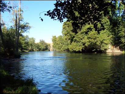
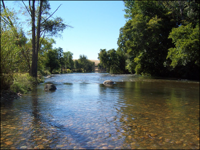
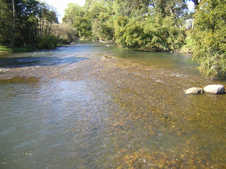
Below is a photo of the 2003 site and the pool section below it as it was just before the 2004 site was built to support it.
LMR 2004 Pre-Project Characterization
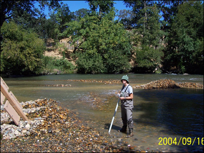
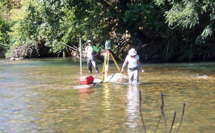
Channel topography, water depth, water surface elevation, velocity, and substrate sizes were measured on-site. Geomorphic analysis was done analyzing the site at several cross-sections using the same methods as used in 2001. 2D model parameters including eddy viscosity and bed roughness were estimated based on field observation and data analysis. 2D model validation data was collected.
LMR 2004 2D Modeling
One aspect that sets SHIRA apart form other river rehabilitation frameworks is that it uses predictive 2D model ing to assess the design hypotheses used in each design scenario in terms of hydrodynamics, bed scour, and habitat availability.
2D model predictions are presented for pre and post -project conditions as well as for conditions in 3 alternative designs. Models were run for the spawning flow only because no rating curve data was available for the site at higher flows due to minimalreleases in the 4 years prior to the project. Brief comments on each spawning flow analysis are provided.
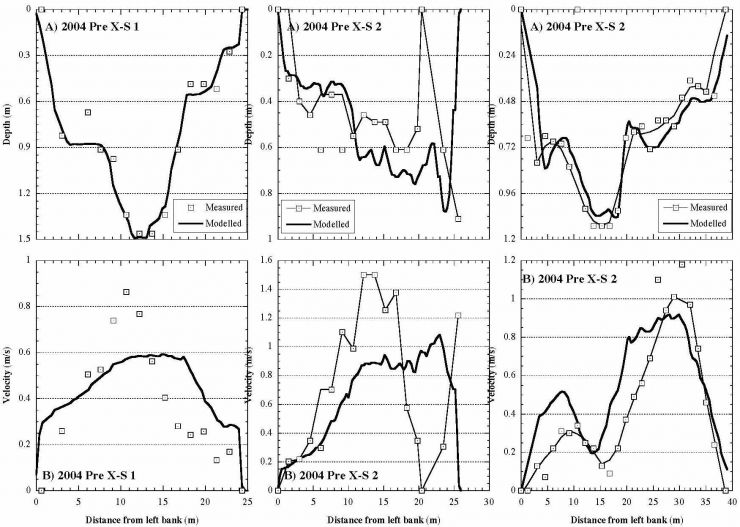
Below is an example of pre-project 2D model validation results from the 2004 project. In XS 2 the model didn't represent the dry bar in the middle, so the flow was not routed properly around it. Other than that, the model matched observations very well. Model performance exceeded standard performance standards as a whole.
LMR 2004 Pre-Project Modeling
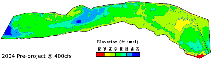
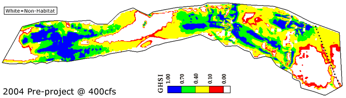
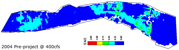
The 2004 pre-project condition was nearly identical to the 2003 post-project condition from 6 months prior, but now the study area was extended downstream to include the next riffle for rehabilitation. That riffle was rehabilitated in 1999 prior to SHIRA, but a thalweg was steadily incising through it. Also, it was in need of an increased bed elevation to enable the new, higher slope to be transmitted downstream in future projects. Evident in this elevation map is a 4' vertical drop in bed elevation between riffle crests. Whereas the 2003 post was designed based on a flow of 500 cfs suitable for that year, in 2004 the spawning flow was back down to 400 cfs, which is close to the long-term average spawning flow.
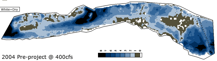
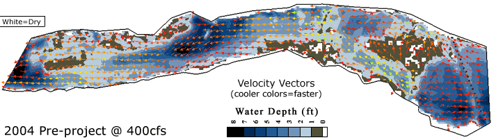
At 400 cfs, much of the 2003-site riffle is exposed or in < 1' of depth. A deep pool resulted at the top of project due to gravel addition. At the 1999-site riffle, depth patterns show a primary chute on river left and a secondary chute on river right. A deep, constricted pool occurs between the two riffles and a deep pool occurs at the end of the model domain due to historical gravel mining.
Predicted velocities over the 1999-site riffle range from 1.5-3 .5 ft/s . The 2003 -site riffle shows continued good functioning of the notch that protects the majority of the riffle crest from scour. High velocities are problematic at the end of 2003 -site riffle exit where the bed slope transitions from the new higher value to the pre-existing low value. The pool between the two riffles has velocities of 0-2 ft/s.
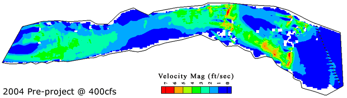
Predicted flow patterns indicate that downstream of the 2003 site flow constricts through the pool and beyond where bedrock outcrops and LWD clog the river right side of the channel. Convective acceleration through this constricted zone explains why the 1999-site riffle is scouring in the downstream direction in line with the constricted flow path . Over the 1999 site, flow divides around the main bar into the two chutes. Some flow goes over the gravel added to the far right of the channel where another small chute is present.
During this Intermediate stage of multi-riffle rehabilitation, there were glaring problems predicted using SHIRA. First, the pool at the top of the reach is too deep to be used for spawning habitat, due to the backwater effect. Second, the 2003-site riffle crest has too much lateral depth variation and notch area, yielding exposed gravels unavailable for spawning. Throughout the 2003-site riffle, velocities are too high and depths too low, as expected for this intermediate design. Downstream, the 2004 appears to be good quality, but the Intervening pool is too long and poorly configured to provide diverse rearing, spawning and adult holding habitat . By using SHIRA to consider two riffle-pool units at once in 2004, it is hoped to resolve these issues simultaneously in the new designs.
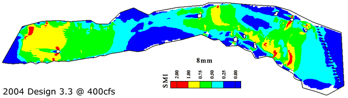
8 mm gravels were predicted to be susceptible to scour over much of the 2003-site riffle due to the excessive slope, but only susceptible to intermittent scour over the 1999-site riffle where infrequent, strong turbulent bursts could yield forces exceeding the average predicted conditions at this discharge.
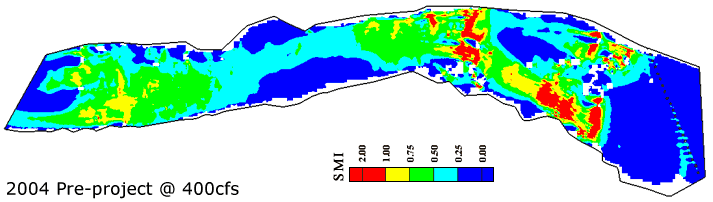
32 mm gravels were predicted to be susceptible to scour over localized areas of convective acceleration within the 2003-site riffle due to the excessive slope and boulder constrictions . No scour was predicted for the 1999-site riffle at this discharge.
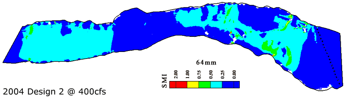
64 mm cobbles were predicted to be stable over the entire model domain except for a few highly localized points of convective acceleration into the 2003-site riffle notch and around boulders at this discharge.
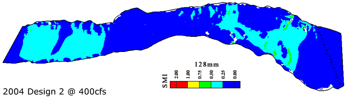
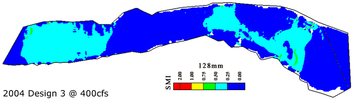
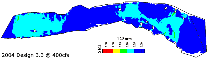
128 mm cobbles were predicted to be stable at this discharge.
LMR 2004 Design Concepts
In the 3 alternative designs for 2004, gravel/cobble was distributed to the deep pool at the top of the project area
that was caused by gravel placement during 2003 so as to return back to usable spawning habitat, to the 2003-riffle
crest to improve its functionality, and to the 1999-site riffle that was the next one downstream. Unlike past years,
the differences among designs are more subtle, but in this stage there was a large emphasis on riffle-pool-riffle
interactions.
LMR 2004 Design 1
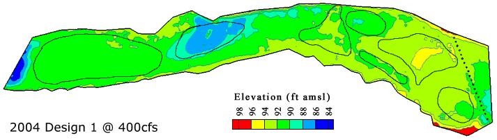
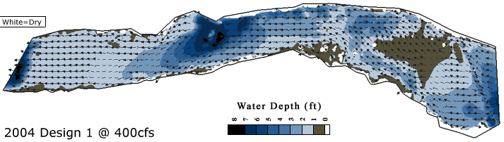
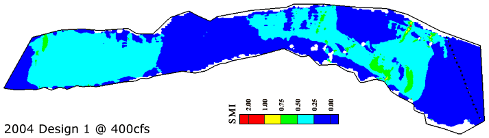
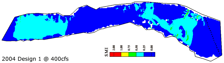
This was the second stage of a 2-stage project. The primary goals were to "soft- land" velocity and depth at the 2003 site as planned by build ing up the crest elevation of the 1999 site. In Design 1, the downstream riffle (1999 site) receives a single riffle crest. For this design we filled in the pool at the top of the reach, slightly raised the notch elevation, scraped the 2003-site riffle crest down, and turned the 1999-site riffle into a big, broad , flat riffle. Total fill volume for this design is 1728 cubic yards.
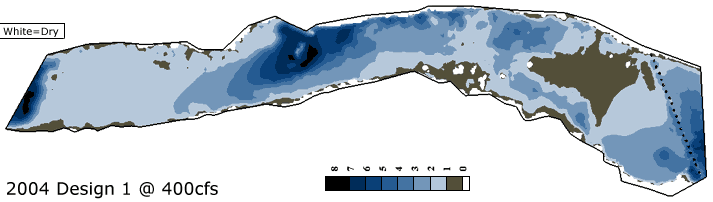
Predicted water depths for this design show that the 2003 site no longer has exposed areas on the riffle and the depth of the pool upstream of it has been reduced to an appropriate level. The 1999-site riffle is predicted to have a uniform depth of 1-2' .
Predicted velocities over the 2003-site riffle ranged from 2-5 ft/s, with much more area in the 2-3 ft/s range than was present pre-2003 or post-2003. The 5-7 ft/s velocities associated with the notch and riffle exit post-2003 would be reduced significantly to 3-5 ft/s, as desired. Predicted velocities over the 1999-site riffle remained similar to the pre-existing conditions, but with a larger area of 2-3 ft/s, as desired.
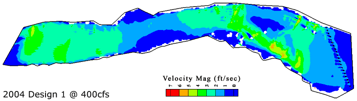
Predicted flow patterns for the 2003-site riffle remain similar to the pre-existing condition, except for improved flow volume over the the riffle crest. For the 1999-site riffle flow pattern diversity is significantly decreased to yield fairly uniform flow conditions over the riffle.
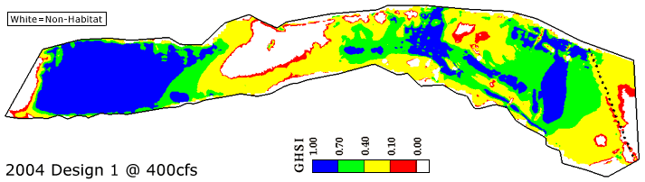
The primary predicted benefits of Design 1 would be the format ion of high quality habitat over the riffle crest of the 2003 site, a broad area of medium quality habitat around that, the recovery of usable habitat at the top of the project area, and an increase in area of high quality habitat near the riffle exit. For the 1999 site, the predicted habitat quality is high quality throughout. However, this design would diminish habitat heterogeneity, which could be a problem that is not picked up by the 2D model ing approach.
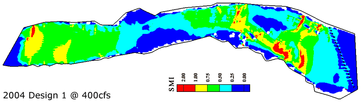
8 mm gravels were predicted to be susceptible to scour over a greatly reduced area of the 2003 site at this discharge . The likelihood of intermittent scour has been increased over the riffle exit of the 1999 site, because that is where the newly created slope stops and there is a drop back to the pre-existing condition, until the slope is carried further downstream in subsequent years.
32 mm gravels were predicted to be susceptible to scour over a few localized areas of convective acceleration within the 2003-site riffle due to the excessive slope and boulder constrictions. No scour was predicted for the 1999-site riffle at this discharge.
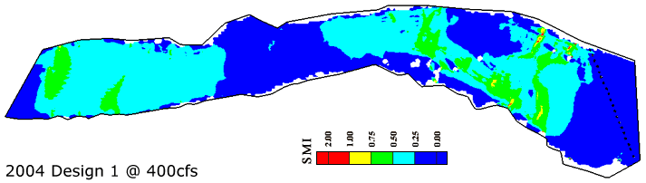
64 and 128 mm sized cobbles were predicted to be stable over the entire model domain at this discharge.
LMR 2004 Design 2
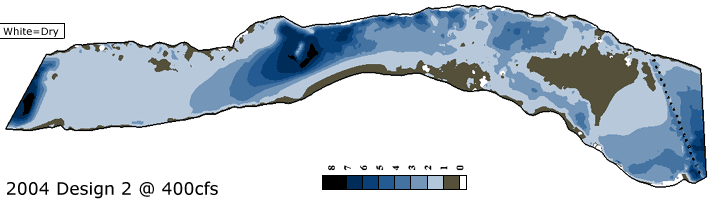
This was the second stage of a 2-stage project. The primary goals were to "soft-land" velocity and depth at the 2003 site as planned by building up the crest elevation of the 1999 site. A secondary goal was to constrict the pool between the sites to improve sediment passage through the pool at high flow. In Design 2, 92.0 the 1999 site receives two riffle crests separated by a shallow trough. For this design, the 2003 site was altered the same as in Design 1. Gravel was placed to the river - left of the pool between the 2003 and 1999 sites to further constrict the deep pool to enhance sediment passage and to serve as a gravel source for the 1999 site after future high flows. Total fill volume for this design was 1826 cu yds.
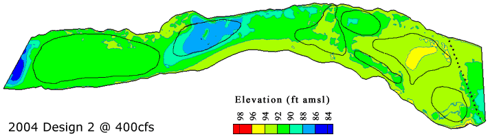
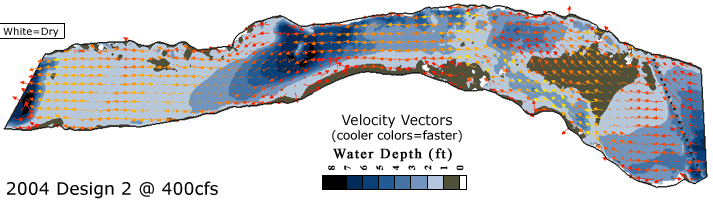
At 400 cfs, predicted depths for the riffles were very similar to Design 1, with the 1999 site trough not resolved at the pictured resolution.
Predicted velocities over the 1999-site riffle ranged from 2-4 ft/s. Little difference was observed compared with Design 1.
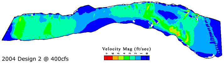
Predicted flow patterns are similar to those for Design 1, except that there is a secondary flow cell along the pool constriction.
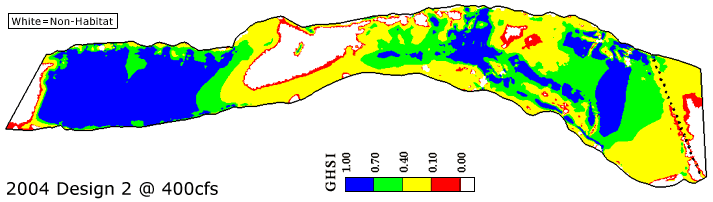
The primary predicted benefits of Design 2 are highly similar to Design 1, but with the addition of habitat complexity induced by low- relief riffle crests and troughs over the 1999 site. The 2D model does not distinguish any benefit of multiple crests and troughs, but experience suggests that there might be value not reflected in modeling algorithms at this time.
8 mm gravels were predicted to be susceptible to scour over a greatly reduced area of the 2003 site at this discharge . The likelihood of intermittent scour has been increased over the riffle exit of the 1999 site, because that is where the newly created slope stops and there is a drop back to the pre-existing condition, until the slope is carried further downstream in subsequent years.

32 mm gravels were predicted to be susceptible to scour over a few localized areas of convective acceleration within the 2003-site riffle due to the excessive slope and boulder constrictions . No scour was predicted for the 1999-site riffle at this discharge.
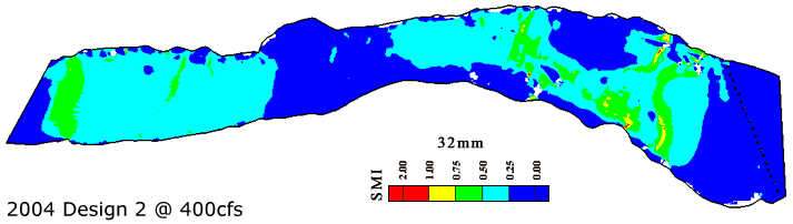
64 and 128 mm sized cobbles were predicted to be stable over the entire model domain at this discharge.
LMR 2004 Design 3
This was the second stage of a 2-stage project. The primary goals were to "soft -land" velocity and depth at the 2003 site as planned by building up the crest elevation of the 1999 site. The idea for Design 3 was to take the best elements of Designs 1 and 2 and put them together. Thus, the 2003 -site riffle is very similar to that for Design 1, except that the secondary flat, transverse gravel bar was widened to provide more habitat and the pool at the top of the project was filled in more. For the 1999 site, a single riffle crest on a broad, flat riffle was employed. The lateral bar constricting the pool in Design 2 was also used in Design 3. Total fill volume was 2126 cu yds.
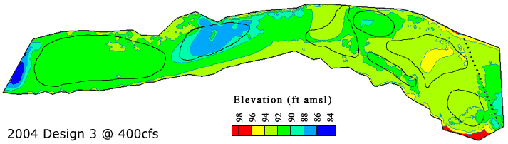
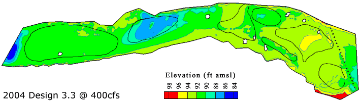
At 400 cfs, predicted depths for the riffles were very similar to Design 1, with the addition of a 1-2' deep transverse bar on the lower end of the 2003-site riffle, as desired.

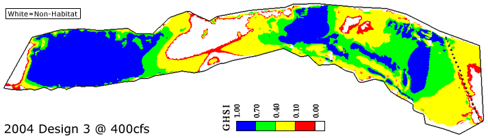
Predicted velocities over t he 2003 -site riffle ranged from 2-5 ft/s. Unlike Design 1, no 5-7 ft/s velocities were present any more in the notch and riffle exit . Predicted velocities over t he 1999-site riffle included a larger region of 3-5 ft/s flow, but now nowhere over 5 ft/s.
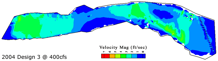
Predicted flow patterns are similar to those for Design 2.

Design 3 was predicted to achieve every thing the other designs provide, but also adds a larger area of high quality habitat in the lower region of the 2003-site riffle.
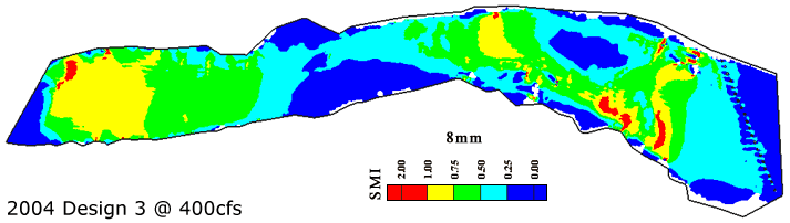
8 mm gravels were predicted to be susceptible to scour over a greatly reduced area of the 2003 site at this discharge . The likelihood of intermittent scour has been increased over the riffle exit of the 1999 site, even relative to Design 1, because that is where the newly created slope stops and there is a drop back to the pre-existing condition, until the slope is carried further downstream in subsequent years.
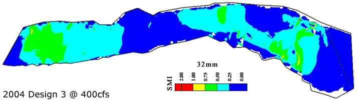
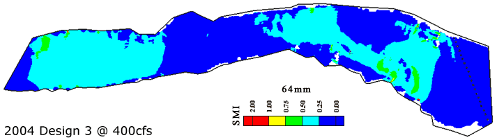
32 mm and coarser-sized gravels and cobbles were predicted to be stable in the model domain at this discharge.
LMR 2004 Design 3.3
The goal of Design 3.3 was to explicitly model the impacts of placed boulder clusters on flow, scour, and habitat patterns. Boulders have ben used at all Mokelumne rehabilitation sites, but were only previously incorporated into the SHIRA design process in 2002. Boulders can be used to help direct flow paths and to create habitat heterogeneity. Spawning on the Mokelumne is highly concentrated around boulders.
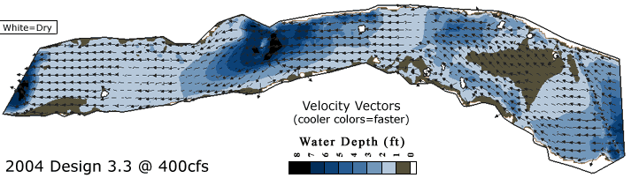
At 400 cfs, boulder clusters add exposed elements to the channel, which may be used by birds hunt ing for prey.

Boulder clusters were predicted to have a strong impact on velocity magnitude at 400 cfs. Flow accelerates around each boulder creating higher velocities. Behind each boulder is a low velocity eddy. Strong fluid shear occurs between the these velocity zones, which may provide spawners with an enhanced ability to access fast flow without having to use as much energy.
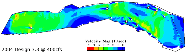
Flow patterns are not significantly altered from those predicted for Design 3. Flow is focused a bit more into the channel center near the 2003-site riffle exit . Secondary flow cells occur behind and in some cases adjacent to boulder clusters, but these are not viewable at the resolution of the shown maps.
From an GHSI perspective, boulder clusters appear to reduce habitat quality by creating zones of overly high velocity adjacent to boulders and zones of sluggish velocity behind them. A study by Wheaton et al. (2004c} on the Mokelumne found that >9 5% of area around boulders was used for spawning, indicating insufficient area in boulders to meet spawning demand. SHIRA's 2D modeling tools are helpful to assess the impact of boulders on flow speed, flow pattern, and scour pattern, but are less useful for assessing the habitat value of boulders at this time. This could be improved in future years.
In some locations boulder clusters were predicted to increase the area of scour of 8 mm gravels, while in other locations there reduced it. When a boulder cluster is placed on a broad, flat riffle crest, such as on the 1999-site riffle, it will increase scour by accelerating flow beyond the threshold in a location that is already swift. Peripheral placement of boulders can create sheltered areas with fine gravel and slower moving velocities suitable for steelhead spawning or juvenile rearing.


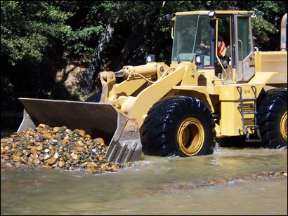
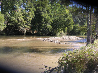
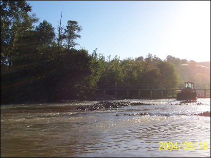
LMR 2004 As-Built
The post-project condition reasonably matches the construct ion plan, except the front loader could not get all the way over to the right bank close to the 2003-site riffle exit , due to the presence of much LWD. and deep water. The notch is not as articulated as planned. Also, due to the front loader's tire tracks, it was possible to create numerous transverse dunes -0 .5-1 ' in amplitude throughout the project area, as an experiment to see if spawners would use them. Even larger such transverse bars were evident in the 2003 pre-project condition, and it is unavoidable to have tire tracks, so it was thought to try to incorporate them into the design this time.
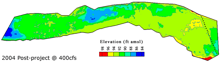
All the major features of Design 3.3 are evident in the post- project condition, though not to exact replication given the vagaries of real-world construct ion. Some of the transverse bar features created using tire tracks are evident on the 2003-site riffle. The lateral bar constricting the pool ended up wider and with a steeper side-slope than planned.
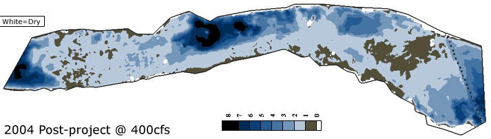
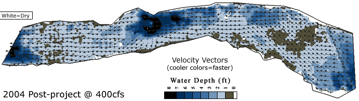
The pattern of velocity magnitudes were predicted to be similar to that designed, but with highly localized points of convective acceleration induced by local protuberances. Velocities of 4-5.5 ft/s occur over the 2003-site riffle crest where flow is extremely shallow and over the 1999-site riffle exit where a slope break occurs at the end of the project area.
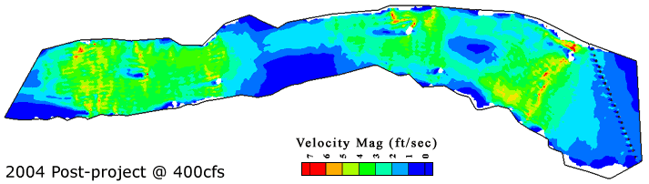
The flow pattern is highly similar to that predicted in Design 3.3, except that there are higher velocities on the river left side of the 2003-site riff le near the riffle exit. Flow is not as tightly focused in the notch as it was in the design.
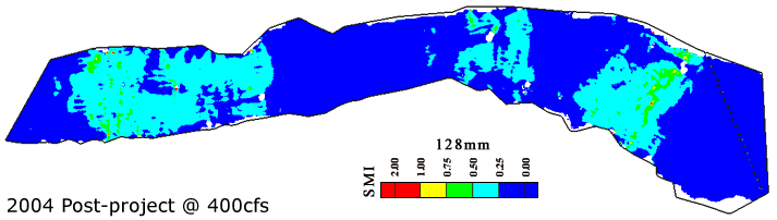
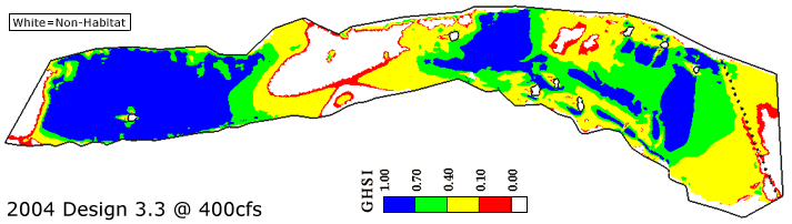
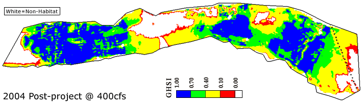
The post -project predicted region of high quality habitat ended up being even larger than predicted for Design 3.3. The reason for this was that a less accentuated notch increased velocities over more of the 2003-site riffle, yielding better quality habitat. The pools at the project's top and bottom were not filled in as extensively as planned, yield ing larger non-spawn ing habitat areas than planned, but not enough to be concerned about. Overall, from pre-2003 to post-2004, there was a 444% increase in high-quality habitat. This demonstrates that science-based, predictive design incorporat ing both geomorphology and ecology yields a far better outcome than an approach focus ing solely on ecology, as that alternative would never have made such a dramatic change to the 2003 project site.
8 mm gravels are susceptible to scour over local protuberances and broadly over the 2003-site riffle crest at this discharge. The likely cause of this is that the notch was overly filled in during construction while =2000 tons of gravel was moved over it to be placed elsewhere.
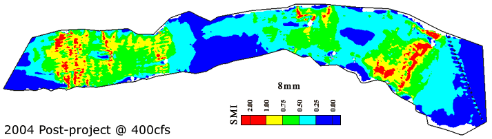
32 mm gravels were predicted to be stable over most of the project domain, except for scattered protuberances on the 2003-site riff le crest at this discharge.
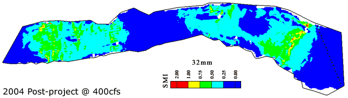
64 mm and coarser-sized cobbles were predicted to be stable over the site at this discharge.