Shira Framework
Cycle 5 Flowchart
As with most engineering approaches, SHIRA advocates comprehensive pre-project assessment, planning and design phases followed by construction, post-project assessment, monitoring and hopefully adaptive management. During each of seven phases, four primary modes (data collection, conceptualization, scientific experimentation, and modeling) are used iteratively to collect and analyze data on which flexible and informed decisions can be based. SHIRA places extra emphasis on a design development stage, which is largely underdeveloped in SHR and river rehabilitation more generally. The schematic below shows the entire SHIRA framework:
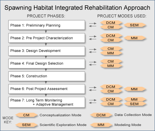
Phase 1: Preliminary Planning
Phase 1: Preliminary Planning
Set goals, select sites, evaluate constraints
Literature Review
Determine what previous studies have already learned about the river and related scientific concepts.
Historical Analysis
Compile maps, aerial photos, existing data, and other resources to evaluate the existing conceptual model underlying the planned project.
Scientific Questions
Develop scientific questions that can be answered by treating project as an experiment.
Site Selection
Assess site suitability for the planned project in light of the conceptual model.
Project Goals
Clearly specify project goals. Evaluate suitability of goals. Confirm that tools can achieve goals.
Project Constraints
Determine resources available for job. Check site access and project timing. Assess potential negative impacts. Know the regulatory process.
Assess overall project feasibility, appropriateness of project goals, and potential for science-based testing.
Phase 2: Pre Project Characterization
Phase 2: Pre Project Characterization
Document baseline conditions at relevant spatial scales
Conceptualization
Develop a preliminary conceptual model of the existing conditions and processes at the site.
Data Collection
Quantify baseline monitoring variables. Constrain model parameters.
Data Analysis
Perform geomorphic, hydrologic, ecologic, and other data analyses to interpret and extrapolate data.
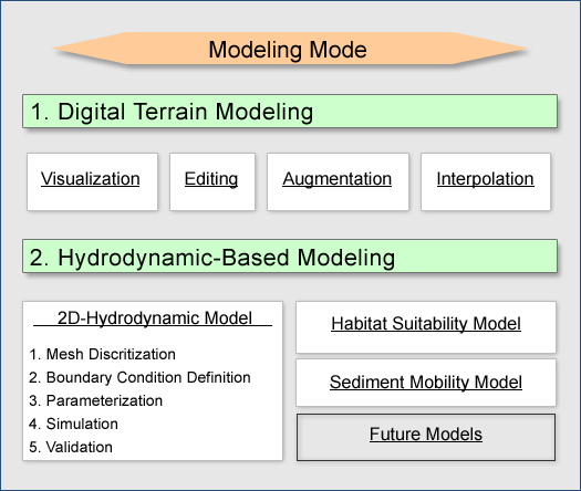
2D Modeling
Develop and run simulations capable of resolving processes at the same 0.1-1 m scale that fish and sediment experience the flow at the site.
Collect, analyze, and review all data to yield the best conceptual model, project goals, and lessons for design alternatives and construction.
Phase 3: Design Development
Phase 3: Design Development
Create Alternatives & Test Design Hypotheses
A. Identify Design Constraints and Opportunities
Draw on conclusions from SHIRA phases 1 and 2.
B. Develop Preliminary Alternatives
Conceptualization, Landform Sketches, Process Design Hypotheses, and DTM Creation.
C. Test Design Hypotheses
Use modeling mode and data analyses to evaluate the likely outcome of each preliminary alternative.
D. Design Refinement
Improve best preliminary alternative(s) based on test results. Add heterogeneity elements, such as large wood and boulders.
Phase 4: Final Design Selection
Phase 4: Final Design Selection
Compare alternatives & choose one for construction
A. Cross-Compare Designs
Metrics of non-habitat area converted to habitat, existing-habitat area improvements, gravel efficiency (habitat/m3), success of testable design hypotheses, scour depth and area, habitat heterogeneity, and beneficial qualitative features.
B. Share The Vision
- Explain SHIRA Project.
- Present alternatives to experts/ stakeholders/ public.
C. Final Selection
Use combination of objective analysis, expert judgement, and societal values to select final design.
D. Final Design Refinement
- Final adjustments to selected design.
- Grading plan and construction docs.
- Regulatory procedures.
There is no one "true" or correct answer to design for an open environment
Phase 5: Construction
Phase 5: Construction
Implement final design
A. Designer-Contractor Interaction
Communicate key goals and design elements to construction contractor.
B. Observe/Aid Construction
Help with staking project. Be on site to address unexpected problems, help craft feature details, and spot check progress.
Phase 6: Post Project Assessment
Phase 6: Post Project Assessment
Document as-built conditions and construction accuracy
Data Collection
Quantify baseline monitoring variables.
Constrain model parameters.
Data Analysis
Perform geomorphic, hydrologic, ecologic, and other data analyses to interpret and extrapolate data.
2D Modeling
Develop and run simulations capable of resolving processes at the same 0.1-1 m scale that fish and sediment experience the flow at the site.
Collect, analyze, and review all as-built data to evaluate construction accuracy and check predictions against reality.
Phase 7: Long Term Monitoring & Adaptive Management
Phase 7: Long Term Monitoring & Adaptive Management
Answer specific scientific and management questions to guide future effort
Geomorphology
Site-scale sediment budget
Bed armoring and roughness
Flow convergence routing
Topographic change detection
Topographic change processes
Local Chemistry
Temperature distribution
Oxygen distribution
Substrate permeability
Substrate organic content
Fish Populations
Adult immigration video/Vaki
Juvenile emigration rotary screwtrap
Carcass survey
Spawner survey
Habitat Utilization
Redd mapping
Coded-wire tagging juveniles
Radio-tracking fish
Electro-fishing
Seining
Snorkel surveying
Community Interactions
Invertebrate assemblage, food web
Riparian vegetation, cover, shading
Predator-prey studies
Incubation success
Mortality causes
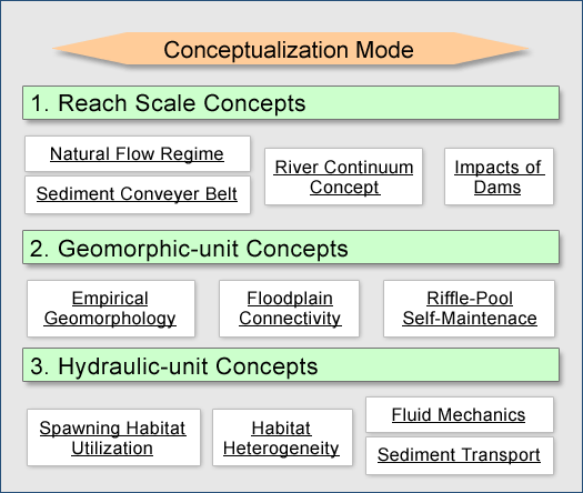
Conceptualization Mode
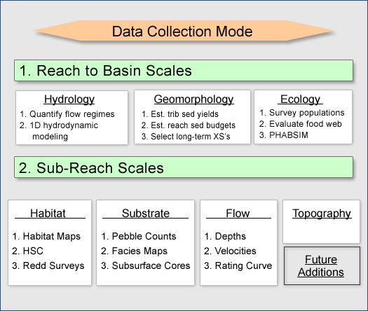
Data Collection Mode
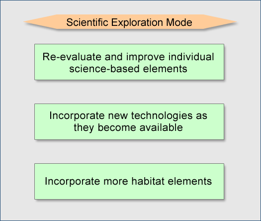
Scientific Exploration Mode
Modeling Mode