
TR Pre-Project Characterization
Physical Controls on Rivers
Input controls are those that affect the river’s flow and sediment supply regimes. Natural “genetic” controls include topography, geology, climate, soils, and vegetation, with the topographic variables of upslope contributing area and local slope providing a particularly strong influence on landscape processes (Montgomery 1999; Montgomery and Buffington, 1997; Montgomery et al., 1996). Anthropogenic input controls include land use, dams, and diversions. Land use affects the gross supply of water and sediment to streams (Bosch and Hewlett, 1982; Jacobson, 1995; Pasternack et al., 2001; Constantine et al., 2005), whereas dams and diversions determine the timing, magnitude, frequency, and rate of change of delivery of inputs to downstream areas (Williams and Wolman, 1984; Kondolf, 1997; Grant et al., 2003).
Boundary controls primarily affect fluvial processes at the hydraulic unit (0.1-1 channel widths) and geomorphic unit (10 channel widths) scales and are typically limited to the reach (100-1000 channel widths) in which they occur. Boundary controls affect channel structure and mediate the response of the channel to flow regime impacts by directing or restricting channel change (Lisle, 1986; Abbe and Montgomery, 1996; Thompson et al., 1998; USFWS, 1999). As a boundary control, valley confinement and valley width variation affects many gravel-bed rivers (Jacobson and Gran, 1999; Coulombe-Pontbriand and Lapointe, 2004). Compared to unconfined channels, the hydraulics of valley-confined channels tend to concentrate flow and bed shear stress in a channel’s center with increasing discharge, creating reaches with high transport capacity (Leopold et al., 1964; McBain and Trush, 2000; Constantine et al., 2003). The persistence of pool and riffle sequences has also been related to boundary controls such as bedrock outcroppings, bar features, logjams, and valley geometry (Lisle, 1986; Thompson et al., 1998; MacWilliams et al., 2006). Large changes in relative cross-sectional area between pools and riffles as a function of discharge yield hydraulic “reversals” in which velocity and bed shear stress are greater for riffles than pools at low discharge, but then are greater for pools than riffles at high discharge (Keller, 1971; Carling, 1991; Thompson et al., 1998; MacWilliams et al., 2006).
Anthropogenic boundary controls occur at subreach spatial scales and involve direct channel interventions. Because anthropogenic boundary controls generally constrict channels and reduce their roughness (Erskine, 1992; Surian and Rinaldi, 2003), they increase transport capacity and decrease physical-habitat diversity, reducing ecological productivity and diversity (Negishi et al., 2002; Merz et al., 2004; Merz and Ochikubo Chan, 2005). Bed armoring, vegetation encroachment, and levee formation can indirectly result from flow regulation (Williams and Wolman, 1984; Kondolf, 1997; USFWS, 1999). Although such input alterations cause these boundary controls, the effect of these boundary controls is on the boundary and thus its designation as an anthropogenic boundary control. Bank stabilization is used to prevent channel migration and reduce bank erosion that produces sand, silt, and clay (Chang, 1988). Engineered in-stream structures also exist to constrain or aid channel dynamics in association with dams, check dams, bed sills, artificial riffles, boulder clusters, and wood (Abbe et al., 2003; Cederholm et al., 1997; Newbury et al., 1997; Thompson and Stull, 2002). In-stream structures may be used to promote fluvial diversity in support of ecological health (Hunter, 1991; Thompson and Stull, 2002; Wheaton et al., 2004c, Elkins et al., 2007). Artificial riffles are frequently prescribed for slope control and consist of weir like arrangements of large boulders (0.5-2.0 metric ton) that are often cabled (Thompson, 2002; Saldi-Caromile et al., 2004).
Characterization Methods
To evaluate the effectiveness of river rehabilitation and/or flow re-regulation in the Lewiston hatchery Reach, a combination of empirical, analytical, and numerical methods were used to determine the impact of anthropogenic boundary controls on salmonid rehabilitation. The impact of anthropogenic boundary controls on reach and geomorphic unit scale hydraulic and geomorphic processes was evaluated by using longitudinal profile and hydraulic-geometry analyses. Long-profile analysis can allow determination of dominating factors controlling slope distribution. Cross-sectional hydraulic geometry can be used to analyze channel response to flow re-regulation over a wide range of discharges beyond that observed during the study period. Geomorphic unit self-sustainability of the riffles and pools present in the LHR was evaluated by comparing log-log plots of velocity versus discharge for riffle and pool sections to discern the presence of a hydraulic reversal mechanism in the reach associated with relative cross-sectional area (Keller, 1971; MacWilliams et al., 2006).
Two-dimensional (2D) depth-averaged computational modeling was done to estimate channel hydrodynamics, sediment transport regime (defined in terms of a range of Shields stress values), and anadromous fish habitat patterns at the 1-m spatial scale relevant to key geomorphic and ecologic functions of the channel. Quantitative analyses necessitated development of a high-resolution digital elevation model (DEM) as well as gathering hydraulic and bed material data. The 2D model node values of depth and velocity for each discharge evaluated were plotted to analyze trends in hydraulic distribution with increasing stage. The flow release regime for Lewiston Dam was used to select appropriate discharges for assessing the impact of boundary controls on key ecological and geomorphic processes. The discharges studied were the autumnal anadromous fish spawning flow (300 cfs, 8.5 m3/s), late summer adult fish holding flow (450 cfs, 13 m3/s), early summer anadromous fish attraction flow (2500 cfs, 70.8 m3/s), and the peak dam release during the study (6000 cfs, 170 m3/s). These flows are re-regulated releases from Lewiston Dam associated with the effort to provide a more natural flow regime. Floodplain structures and bridges prevent any substantially higher peak releases from occurring in the near future.
A detailed topographic survey was conducted using a Topcon GTS-802A robotic total station in summer 2003 yielding 15,284 points from the bed, boulders, edge of water, and water surface elevation within the 450 cfs (13 m3/s) channel. A standard feature-based surveying method was used (Wheaton et al., 2004b) yielding a sampling density of 1.3 pts/m2. Water surface elevations along the study reach were measured at 8.5, 13, 127.4, and 170 m3/s relative to the NAVD88 vertical datum. Geomorphic features within the study reach were identified, surveyed, and incorporated into the DTM.
Fourteen cross sections were selected to characterize the geomorphic unit variations in the LHR (Fig. 5). Wolman pebble counts (Wolman, 1954) were performed on cross sections 1, 2, 3, 4, 10, 11, 13, and 14. Grain size distributions were calculated for each cross section and averaged for the project reach. Velocity validation measurements were recorded at cross sections 1, 2, 3, 13, and 14 at a discharge of 13 m3/s. Flow conditions were too dangerous to obtain velocity data at the highest discharges. Cross section endpins were surveyed with the Topcon GTS-802A so that field data could be compared to model predictions for the same location. Depth and velocity were measured at 1.5 m intervals between surveyed endpins. A Marsh-McBirney Flo-mate (±33 mm/s) mounted to a depth setting wading rod was used to estimate average velocity as the point velocity at 0.6•depth, because the water was shallow (Pasternack et al., 2006). Positional accuracy and observation resolution was much finer than the scale of bed features (5-10 m) and similar to 2D model node spacing.
A DEM of the study reach was constructed using the surveyed topographic points in Autodesk, Land Desktop 3. The four iterative stages of DEM development as described by French and Clifford (2000) were implemented: interpolation, visualization, editing, and augmentation. First, survey data were interpolated and a surface defined respecting breaklines. Next, the surface was visualized as a map and edited to remove obvious interpolation errors. The revised surface was visually verified in the field to check for poorly represented areas in the DEM. Further iteration was done as needed. All 14 cross sections and a thalweg profile were extracted from the DEM using Land Desktop. At each cross section, mean depth, top width of flow, width-to-depth ratio, wetted perimeter, hydraulic radius, and area were calculated at 0.3-m intervals from the 8.5 m3/s water surface elevation to a water surface elevation 4 m above.
Boundary controls have been noted to have an impact on hydraulic geometry relations in cases where channel width is constrained (Singh, 2003). Holding one variable relatively constant (for example, channel width), the hydraulic response will be largely dictated by changes in nonstatic variables such as depth and velocity, which may have an impact on geomorphic processes such as riffle and pool sustainability, and thus spatial nested geomorphic features necessary for salmonid fisheries. Ceteris paribus, unforced riffles and pools are considered geomorphically self-sustainable over time if the local bed shear stress over pools exceeds that over riffles at some discharge above bankfull so that the existing topographic variation is maintained as long as sediment is supplied to the riffle-pool sequence (Keller, 1971; Carling, 1991; Clifford and Richards, 1992; Booker et al., 2001; MacWilliams et al., 2006). Cross-sectional analyses of riffle-pool sustainability have yielded somewhat contrasting results depending on the resolution of the tools used to study the phenomenon. If a hydraulic reversal is present in mean flow variables, then it will also be present in local ones, though the converse is not true (McWilliams et al., 2006). Thus, analysis of mean flow conditions is a conservative predictor of riffle-pool sustainability. Cross sections were analyzed to estimate the effect of increasing discharge and channel geometry on hydraulics and riffle-pool self-sustainability. At-a-station hydraulic geometry equations (Leopold and Maddock, 1953) were used to develop relationships between width, depth, and velocity as a function of discharge. A ternary diagram was constructed to compare the width, depth, and velocity exponent values (b, f, and m). To test for riffle and pool sustainability via a hydraulic reversal, log-log plots of velocity versus discharge were constructed and compared for all riffle and pool units. Also, the velocity results from the 2D model were examined for the existence of velocity reversals, as reported later.
Overall Results
Empirical and numerical results both show that anthropogenic boundary controls in LHR significantly impact hydrogeomorphic processes key to river rehabilitation, including the recovery of physical habitat for anadromous fish.
Empirical Results
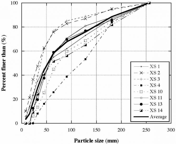
The cumulative frequency distributions of bed material grain size (see figure to the right) shows that the bed is very coarse. The median particle size (D50) of the LHR is 61.1 mm with a standard deviation of 27 mm. Cross sections 2 and 3 are located in the pool after riffle 1; and they have significantly finer bed material, with D50 of 32.1 and 38.2 mm, respectively. Cross sections 4 and 10 illustrate armoring of artificial riffles, with D50 of 120.7 and 72.6 mm, respectively (not counting the large, placed boulders). Along with these geomorphic unit differences in grain size, facies mapping revealed that there are local lateral variations caused by anthropogenic activities. These include finer particle sizes occupying the hatchery outfall scour pools (Fig. 5) as well as 16-32 mm gravels on a relic gravel-injection bar near the end of the reach.
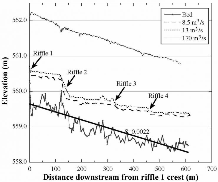
The distribution of slope within the LHR is directly related to anthropogenic boundary controls. The long profile has an overall slope of 0.0022, with significantly higher slopes occurring over rock-riffles (See figure below left). Although the thalweg bed profile shows a lot of variability, the water surface profiles for 8.5 and 13 m3/s clearly identify the artificial riffles located at 0, 125, 270, and 450 m as slope control structures. The profile begins at riffle 1and slopes to riffle 2 at 0.0017. From riffle 2 to the downstream pool located at a bedrock constriction (Figs. 3,5), the channel slope increases to 0.0298. The slope from riffle 3 to 4 is 0.052. The distribution of slope over the rock-riffles is not distributed evenly. The majority of the slope in the LHR is lost over riffle 2. This slope is associated with the dense cluster of wired, 1.25-m-diameter boulders that help hold the smaller cobbles and boulders comprising the feature.
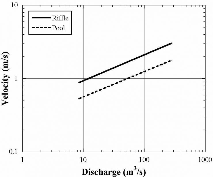
The average hydraulic geometry exponents (b, f, m) for the LHR cross sections are 0.17, 0.50, and 0.33, respectively. These suggest that depth responds most strongly to changes in discharge. Excluding cross section 14, which is not as confined on the river right, the standard deviation of the width exponent is 0.04, so the variation is 15% of the mean value. Comparing pools and riffles, the average hydraulic geometry exponents for the former are 0.19, 0.49, and 0.32, with standard deviations of 0.14, 0.09, and 0.05, while those for the latter are 0.16, 0.51, and 0.34 with standard deviations of 0.05, 0.03, and 0.02. The significance of this close similarity is that there is no reversal expected for any of these variables as discharge increases. For example, for discharges ranging from 8.5-285 m3/s, riffles always have a greater velocity and bed shear stress than pools (See figure above right).
Trinity River LHR 2D Model Results
The primary validation of model-predicted depths and velocities was performed at 450 cfs, which is representative of the July through March low-flow conditions. Lateral patterns of depth predicted by the 2D model at this flow for the five test cross sections closely match those observed, except for cross section 13 that likely experienced scour during the period between topographic surveying and model-validation data collection. The similarity in predicted and observed depths suggests that the topographic survey and associated DEM were of sufficient resolution to capture bed features. It also demonstrates that the physically realistic bed-roughness parameter (Mannings n) used globally was well estimated. In contrast, 2D-model velocity predictions show more scatter relative to observed values, with deviations typically 15-30%. At some points, velocity error is very high. The lateral pattern of velocity magnitude successfully mimics observed conditions, but as is commonly seen with 2D models, smoothing is excessive. This is attributable to inadequate variation in eddy viscosity that cannot be further improved with these models (Pasternack et al., 2006). Using too high of an eddy viscosity value enables greater transference of momentum, hence the smoothing (MacWilliams et al., 2006). A comparison of observed versus model-predicted water surface slopes for 171 m3/s found that the model matched observed conditions very well. Although it would be ideal to have velocity validation for all flows, the pattern of the velocity field is much more uniform at higher flows, and thus the model can be expected to perform better at higher discharges. Model validation of the LHR on the Trinity River once again revealed the strengths and limitations of 2D modeling of shallow gravel-bed rivers along lines previously reported
Click the links below to see the full model results for two of the discharges.


2D Hydraulic Patterns
The distribution of depth and velocity in the LHR is controlled by anthropogenic boundary controls regardless of discharge. From 300-6000 cfs, hydraulic conditions become more uniform, as the spatial patterns of depth and velocity become less influenced by local topography and the artificial riffles, and are governed to a great degree by the channel banks. At 300 cfs, local topography controls the distribution of depth and velocity and is disrupted at the four artificial riffles. Each riffle creates an area of peak velocities and non-uniform flow patterns. Immediately downstream of each riffle eddies and complex flow patterns are present. Between riffles velocity vectors follow local topography, with the bedrock outcropping between riffles 2 and 3 and the gravel injection bar having the greatest affect on flow direction. At 450 cfs, hydraulic conditions change very little, except that riffles 3 and 4 have velocity and depth patterns that deviate less from the surrounding upstream and downstream areas between riffles. At 2500 cfs the channel boundaries become more uniform and the valley walls on the river right and the hatchery walls on the river left govern the velocity vectors. Velocity and depth are comparatively more uniform than lower discharges from riffle 1 to 2. The bedrock constriction after riffle two provides the only area of flow convergence in the channel. Flow direction and magnitude vary little after the bedrock constriction to the end of the model despite differences in depth from local topography. The highest peak flow release from the Lewiston Dam during the study was 6000 cfs. Velocity vectors were omitted for clarity and follow a similar distribution to 2500 cfs, being almost perfectly parallel to the channel banks. Peak velocity zones in the channel did not migrate upstream or downstream, but became more uniform with discharge. There was not a velocity reversal in the channel at 6000 cfs.
Depth-Velocity Joint Distribution
The combination of depth and velocity values in a fluvial geomorphic unit has long been used as an indicator of the meso-scale habitat present (Coarer, 2007). Stewardson and McMahon (2002) showed that depth and depth-averaged velocity are codependent variables, because channel hydraulics exhibit spatial organization. Besides showing how to obtain independent variables, they also used the joint probability distribution of the two codependent variables to show that it is possible to distinguish between two types of channels (i.e. two hydraulic signatures)- one in which velocity and depth are inversely related and one in which they are directly related. The former relation occurs when the channel has a much stronger longitudinal variation in depth than a lateral variation, and vice versa for the latter relation. Whereas Stewardson and McMahon (2002) focus on how these hydraulic signatures can be explained by different channel morphologies, the results of this study demonstrate that the same channel morphology can shift its hydraulic signature as discharge increases. This effect of decreasing relative roughness and increasing prismatic channel conditions on hydraulic signature as discharge increases is known (e.g. Clifford and French, 1998), but its significance for geomorphic and ecological applications has not been sufficiently explored.
The effects of artificial riffles and channel confinement imposed by the hatchery terrace on hydraulic behavior in the LHR are evident in the shifting pattern of the joint distribution of local depth and local velocity as a function of discharge. For discharges <450 cfs, velocity decreases as depth increases. At these discharges, the hydraulic regime is characterized by a wide range of velocities (0-5 m/s) when depth is < 0.5 m and a narrow range of low velocities when depth > 0.5 m. For these discharges, local velocity is controlled by local topographic perturbations that yield pronounced local convective accelerations. Over the artificial riffles, flow is supercritical, so shallow depths have very high velocities; while along rough channel margins, velocities are stagnant. At 2500 cfs, small local topographic perturbations associated with depths < 0.5 m no longer controlled the hydraulic regime. At 6000 cfs, valley confinement by the hatchery terrace yields an essentially prismatic channel with a parabolic lateral velocity distribution, thereby yielding the highest velocities in the deepest part of the channel. Two hydraulic regimes are evident in the channel from these analyses. The first regime is a decreasing velocity with increasing depth associated with convective accelerations over and around larger bed perturbations, such as the artificial “rock-weir” riffles, large individual boulders, and boulder clusters submerged to a depth of 0.5-1.25 m. The less submerged these features are, the more the flow approaches and exceeds the critical threshold. The second regime, which occurred at and above 2500 cfs is the valley confinement hydraulic regime in which velocity increases as depth increases, indicating uniform flow conditions.
Sediment Transport
Boundary controls were observed to influence the distribution of Shields stress in the LHR. Regardless of discharge, Shields stress peaks over the rock riffles in bands perpendicular to the channel edge. At successively higher discharges, confinement causes longitudinal growth of areas of mobility. At 300 cfs, 90% of the channel is predicted to experience no transport, while 6% of the channel is expected to experience selective transport, 2% experiences partial transport, and 2% experiences full transport conditions. Riffles 1 and 2 have exhibit areas of full mobility associated with the tops of boulders in the riffles. Past riffle 2 at the bedrock constriction, an area of selective transport is evident. Riffles 3 and 4 are predicted to experience select transport.
At 450 cfs, patterns of selective transport at the rock riffles and bedrock constriction expand in the downstream direction. Three distinct shear zones are also evident over three boulders past riffle 1 on the river right that have adjacent selective transport patches on the left. Riffle 2 shows two bands of selective transport extending downstream ~ 40 m from the riffle crest. Selective transport is predicted over 11% of the channel, while 2% of the channel is predicted to experience partial transport, and 2% experiences full transport conditions.
Areas of selective transport increase to 74% of the channel and extend from rock riffle to rock riffle at 2500 cfs. Partial transport is limited to 11% of the channel over the rock riffles, the bedrock constriction, and in several lateral bands between riffles 1 and 2.
At 6000 cfs, 64% of the channel is in at least partial transport in a longitudinal band in the center of the channel that begins at riffle 1 and extends downstream. The channel edges experience selective transport at this discharge.
Physical Habitat
The spatial pattern of fall-run chinook spawning habitat quality was predicted with and without consideration of substrate quality. When substrate is not considered, spawning habitat is predicted to be very abundant in the LHR with 77% being at least medium quality at 300 cfs. However, when the substrate habitat suitability index (SHSI) is utilized the 2D model predicted chinook spawning habitat decreases to 36% of the total area. The reason for this is that the bed is heavily armored, with just a few locations with the desirable size range of gravels and cobbles. Regardless of whether or not an SHSI was utilized, little to no chinook spawning habitat was predicted within 15 m of the artificial riffles, indicating that these structures are heavily armored and flow over them is too fast.
The spatial distribution of chinook juvenile and fry rearing habitat are controlled by lateral bars, artificial riffles, and historical gravel injection sites. Chinook fry prefer very shallow and slow-moving channel margins. The majority of the channel is predicted to be either low or very poor quality rearing habitat for chinook fry, as the channel is relatively prismatic. However, the 2D model turns off any element with < 9 cm depth, because that is close to D90 and causes model instability. Thus, the model may be under representing the available fry habitat for a thin strip of sheet flow along each bank. This represents an important limitation for the use of 2D models in habitat evaluation.
Chinook juvenile rearing habitat follows a similar spatial distribution as that of chinook fry, but with a shift in habitat preference to deeper areas with low velocities. The central third of the channel is predicted to range from low to medium quality because the velocity is too high. High quality habitat is present on lateral bars, including remnant gravel deposits at historical gravel injection sites, with the largest being on river left at the end of the reach.
Steelhead, chinook, and coho spawning and fry habitat quality spatial patterns at 300 cfs are relatively similar in reflecting hydrodynamics, but with different percentages of habitat quality classes. Coho and steelhead spawning habitat are both more abundant than chinook spawning habitat. In contrast, the limited amount of chinook juvenile rearing habitat, for steelhead is much more ubiquitous throughout the reach, along with steelhead adult holding habitat, because steelhead juveniles (and adults) prefer 1-3 times higher velocities than chinook juveniles. Whereas steelhead juveniles prefer higher velocities than chinook juveniles, coho juveniles prefer significantly lower velocities, and thus their rearing habitat availability in the reach is greatly reduced. Thus, during fall and winter low flows, this upstream-most reach has a reasonable abundance of steelhead and chinook juvenile rearing and adult holding habitat, but a significant lack of steelhead and chinook spawning habitat. Availability of all coho life stage habitats is inadequate, but that species is not primarily managed for in this reach
A central aim of this study is to quantify the response of physical habitat quantity to changes in discharge, which is a very important component of evaluating the potential effectiveness of flow re-regulation on fisheries restoration. A near doubling of the low-flow release is predicted to cause dramatic decreases in the percent of medium and high quality physical habitat for most species’ life stages within the LHR. The change from 300 to 450 cfs substantially reduces the percent of at least medium quality of the physical habitat for all three species’ life stages except chinook and steelhead juvenile habitat, steelhead adult habitat, and chinook and coho fry habitat, with these last two already near zero. Only 0-3% of the channel is predicted to be at least medium quality fry habitat at 300 cfs, and this increases by 3% for chinook fry and 1% for coho fry at 450 cfs. Medium plus high quality habitat for steelhead adult and juveniles increases by 3 and 1%, respectively; while chinook juvenile habitat of this quality decreases by 13% from 300 to 450 cfs. Spawning habitat for steelhead, chinook, and coho decreases by 37, 22, and 43%, respectively, from 300 to 450 cfs.
When flow is increased from 450 to 2500 cfs the percent of the channel that is at least medium quality habitat decreases sharply for all species’ life stages to below 5% of channel area, except steelhead adult habitat, which still was present in medium or high quality over 27% of the channel. Medium and high quality coho fry rearing habitat showed an insignificant increase in habitat area with this change, but remained below 5%. Further flow increases assessed for Shields stresses were not evaluated for habitat quality, as the channel was too deep and fast to have any significant fish habitat.
Pre-Project Characterization Conclusions
Effect of anthropogenic valley confinement
Anthropogenic valley confinement in the LHR through construction of the Lewiston Hatchery has had the commonly observed effect on geomorphology, hydraulics, and fisheries for alluvial rivers (Bowen et al., 2003; Jacobson and Galat, 2006). Variations in channel width has in many ways been linked to hydraulic conditions that contribute to geomorphic and ecological variability (Coulombe-Pontbriand and Lapointe, 2004). In reaches where channel width is constant, such as the study reach, hydraulic conditions are promoted that lead to monotony in geomorphic form and in resultant ecological habitat. In this study, empirical and numerical tests for the study reach both came to the same conclusion that a confined and restricted width affects existing and potential fisheries restoration. The lack of variation in channel width between riffle and pool sections, coupled with the cross section averaged velocity being always faster over riffles than pools, limits the potential for geomorphic sustainability in the LHR, as no hydraulic reversals in mean conditions were empirically detected. Hydraulic geometry analysis results are reinforced by 2D model results for depth, velocity, and their joint distribution. For flows < 450 cfs, local topographic features control the distribution of depth and velocity between riffles, and channel width displays moderate control on flow vectors. However, at 2500 cfs channel width becomes very uniform and 2D model results show that hydraulic variables display less variability and uniform, subcritical flow conditions dominate. The 2D model did not detect any velocity reversals for the reach. The distribution of Shields stress is controlled by local topography and the riffles below 450 cfs. Increases in discharge cause the distribution of Shields stress to grow from transverse bands associated with the artificial riffles to longitudinal tubes down the central third of the channel, especially at 6000 cfs. Such a distribution of Shields stress shows that the channel banks exhibit a fundamental control on sediment transport and bed morphology in the study reach. The lateral bars between riffles provide the majority of the physical habitat for all lifestages in the LHR, but have unsuitable depths at 2500 cfs. The net effect of valley confinement on physical habitat in the LHR is that shallow water habitat is nonexistent for flows 2500 cfs.
Effect of artificial riffles
Artificial riffles fix the bed slope of the LHR and create local zones of high bed slope, velocity, and Shields stress. The riffle-pool units in the LHR do not appear to be sustainable, as log-log plots of velocity versus depth for riffle-pool sections as well as 2D model results for velocity and Shields stress indicate that riffles are always faster than pools. These results do not account for forced pools associated with vortex shedding and convective acceleration, but flow re-regulation would not induce such forced pools anyway. The artificial riffles are also predicted to experience a “full transport” sediment-transport regime with regards to the median particle size of the reach at all discharges modeled. This instability is verified as riffles 1, 2, and 3 that are heavily armored, implying that smaller gravels have a low probability of occurrence from hydraulic forces. Gravel instability at artificial riffles during flow < 450 cfs has led to infilling of downstream pools, decreasing bed relief and forming monotonous runs. Median particle sizes on some parts of the riffles are adequate for Chinook spawning, but velocities are still too high. Thus, most spawning is predicted and has been independently observed by the authors to occur on lateral bars in the study area between the riffles. Also, Elkins et al. (2007) experimentally created a chute with lateral bars in a different regulated gravel bed river and observed that the fish shifted their spawning pattern to line up on those bars adjacent to the high-velocity chute. These peripheral locations may have poor hyporheic water quality and low embryo survival to the fry life stage.
The potential for salmonid habitat restoration in the LHR by flow reregulation
Existing physical habitat in the reach is of relatively poor quality and diminishes quickly as flow increases. Spawning habitat is not associated with riffles, but rather with lateral bars between the rock riffles. Potentially these areas experience little upwelling and hyporheic flows possibly affecting embryo mortality rates. Riffle velocities are too fast and substrate too coarse for spawning.
River rehabilitation for salmonids requires that suitable habitat be available for all lifestages. At the spawning discharge of 300 cfs, the amount of available medium and high quality spawning habitat as a percentage of the total area is 36% for chinook, 50% for coho, and 44% for steelhead, including significant overlap on the same lateral bar morphologic units. These values drop significantly for even a modest flow increase to 450 cfs and are virtually nonexistent by 2500 cfs. These decreases are linked to the hydraulic response of the channel from unnatural confinement and from the focusing of energy dissipation at oversteepened rock riffles, whereby increases in discharge concentrate velocity and Shields stress on riffles at low flows and in the central thalweg at high flows.
In contrast to the current condition in which flow re-regulation would not improve salmonid habitat, the historical channel configuration lacked confinement and bed steps. An increase in discharge under historical morphological conditions would have activated secondary and tertiary channels across a wide active gravel valley bottom, creating more areas of shallow water with low to moderate velocities that match the conditions desired for fish spawning and rearing identified by USFWS (1999). That would provide ample physical habitat at all flows up to the threshold for filling the valley completely. Jacobson and Galat (2006) performed a numerical experiment comparing historical and modern shallow water habitat for a similarly confined river and reported this type of outcome. Thus, the benefits of a natural flow regime are dependent on the presence of a wide and connected channel-floodplain system.
In determining adequate flows for instream fisheries needs, many have relied on statistical methods that relate fish escapement to frequency of flow occurrence (Jowett, 1997; Maddock, 1999). This approach yields the recommendation of instituting a “scaled down” hydrograph in which the natural timing and duration of discharge fluctuations are mimicked with flow releases by the dam, but at a reduced flow magnitude. However, little or no consideration has been given of geometric constraints that control flow and sediment transport responses to discharge at the hydraulic and geomorphic unit scales. Channel geometry varies significantly along alluvial rivers depending on the local balance of transport capacity versus sediment supply (Leopold et al., 1964; Lisle et al., 2000). This study adds to a growing body of work (Bowen et al., 2003; Jacobson and Galat, 2006) that suggests that consideration of channel geometry, and subsequent controls on its adjustment, need be considered along with flow reregulation as human and biological activities during interim flow regulation can impact channel geometry and thus hydraulic and geomorphic processes that drive physical habitat.
While past studies detail constraints on sediment transport and physical habitat in regulated reaches (Bowen et al., 2003; Jacobson and Galat, 2006), few explicitly define causal mechanisms associated with geomorphic processes at the hydraulic unit and geomorphic unit scales with implications to flow-based restoration strategies. Two fundamental processes will likely govern bed-morphology evolution and thus the abundance of physical habitat in the LHR. At flows < 450 cfs, an unarmored bed will be unstable at step-like riffle units. Any loose particles available for transport will be hydraulically sorted between riffles. At flows > 6000 cfs, the partial transport over riffles gives way to a continuous thalweg experiencing partial transport. The presence of lateral gravel bars is morphological evidence that this pattern of thalweg scour is occurring in the LHR. The implication is that natural development of riffle-pool differentiation and habitat heterogeneity is inhibited at low flow by the artificial riffles and at high flow by anthropogenic valley confinement. As physical habitat in alluvial rivers is considered to be heavily dependent on spatially nested morphologic features, anthropogenic boundary controls that limit or prohibit bedform development can ultimately serve as a limiting factor in salmonid habitat restoration.