
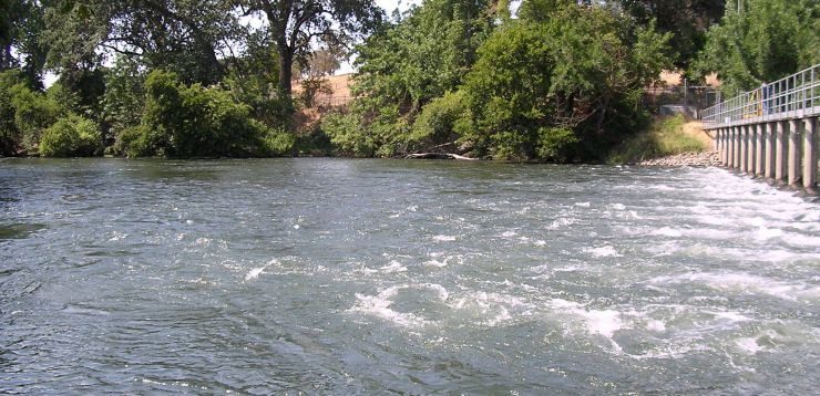
LMR 2003 Site
LMR 2003 Preliminary Planning
A key lesson from past projects was that gravel augmentation is limited by the maximum riffle crest elevation allowable before upstream habitat is submerged potentially resulting in no net habitat gain. It was hypothesized that "slope creation" was needed to continue the gravel augmentation projects . In 2003 a new long-term phase of SHIRA-based rehabilitation began in which slope is being created by placing gravel at the dam and incrementally building projects downstream. Even where spawning habitat quality is high, such as at the 2003 site, slope rehabilitation is needed to promote the reach-scale fish utilization goal set by USFWS (1997).
LMR 2003 Pre-Project Characterization
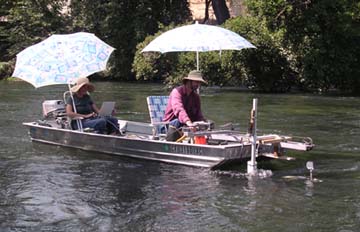
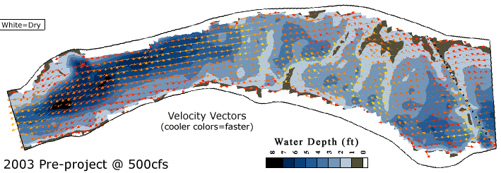
Channel topography, water depth, water surface elevation, velocity, and substrate sizes were measured on-site. Geomorphic analysis was done analyzing the site at several cross-sections using the same methods as used in 2001. 2D model parameters including eddy viscosity and bed roughness were estimated based on field observation and data analysis. 2D model validation data was collected. This year, a 3D acoustic doppler velocity profiler was used to obtain some of the model validation data.

LMR 2003 2D Modeling
One aspect that sets SHIRA apart from other river rehabilitation frameworks is that it uses predictive 2D modeling to assess the design hypotheses used in each design scenario in terms of hydrodynamics, bed scour, and habitat availability.
2D model predictions are presented for pre and post -project conditions as well as for conditions in 5 alternative designs. Models were run for the spawning flow only because no rating curve data was available for the site at higher flows due to minimal releases in the 3 years prior to the project. Brief comments on each spawning flow analysis are provided.
LMR 2003 Pre-Project Modeling
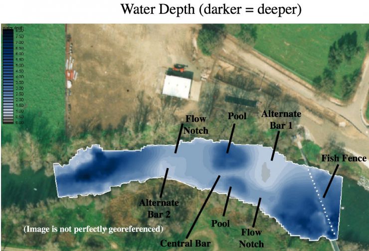
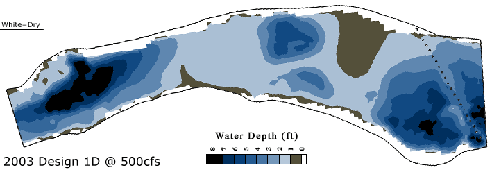
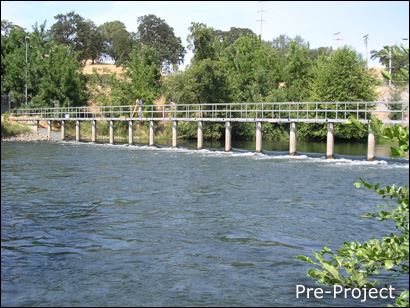
The 2003 site is the farthest upstream riffle below Camanche Dam. The black circles are the piers of the fish barrier and catwalk over the river. In its pre-existing state, this site was composed of a riffle-pool unit whose riffle received historical gravel injections, but is several feet below its pre-dam bed elevation due to incision and a lack of armoring.
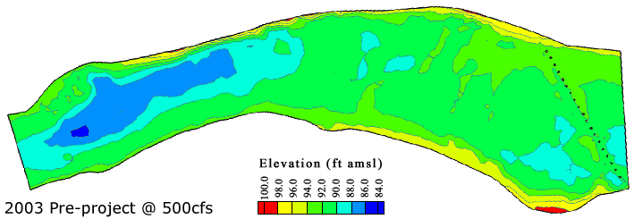
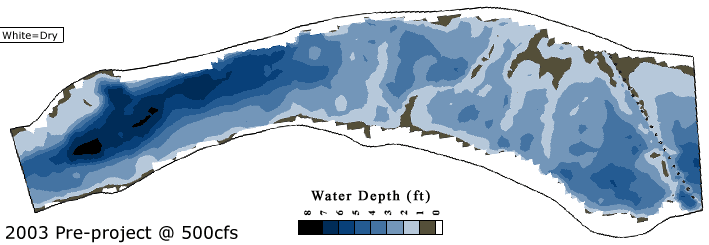
Predicted water depths show large bar on the right right side of the channel and three transverse bars, likely originated from spawner activity. A pool occurs upstream of the riffle on river left where the hatchery in-take is located. The downstream pool is deep due to historic gravel extraction and scour around LWD.
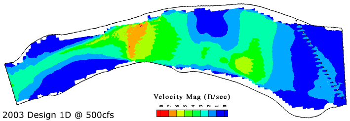
Velocity magnitude was predicted to range from 0-4 ft/s, with a spurious peak adjacent to one of the piers due to model instability. Transverse bar crests have the highest velocities, which are 3-4 ft/s .
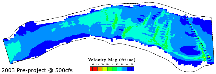
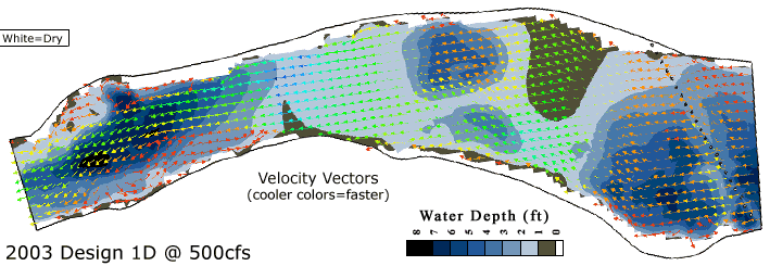
Velocity vectors show that the flow diverges over each transverse bar and then re-converges. The shape of the last transverse bar shifts the flow over to the right bank and then water stays focused on the river right bank through the following pool.
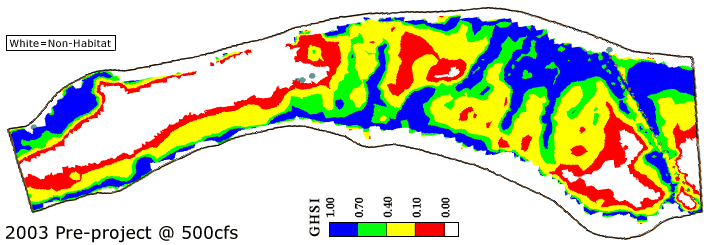
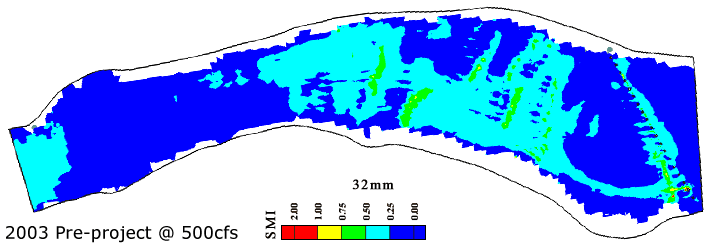
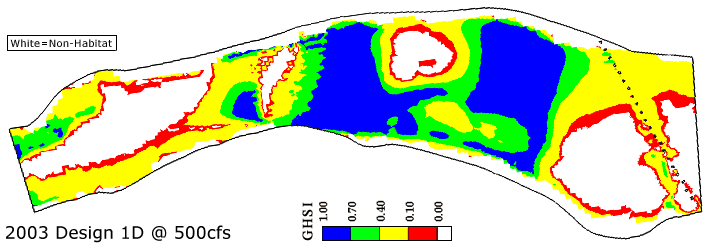
The 2003 site was predicted to have widespread spawning habitat with a range of quality. Transverse bars and the main shallow riffle area on river right had the highest quality habitat, which was been verified by mapping redds. Both pools were non spawning habitat, with a very large unusable region in the downstream half of the study area. These regions could serve as holding habitat.
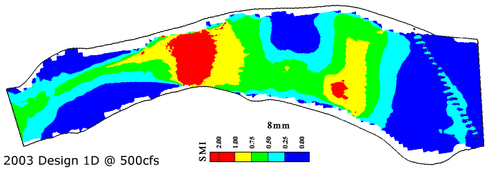
8 mm gravels are predicted to scour on transverse bar crests .
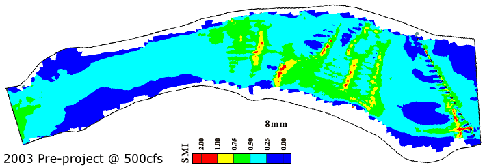
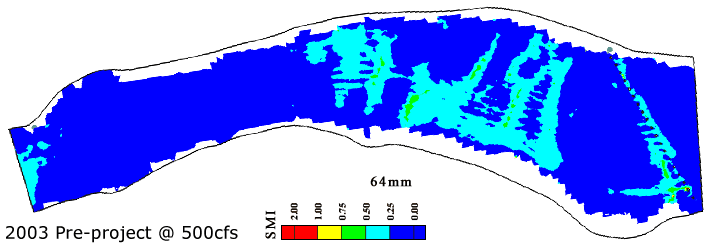
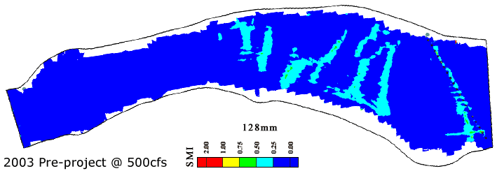
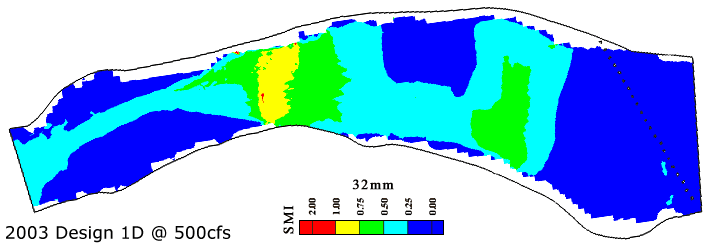
32 mm and coarser-sized bed materials are predicted to be unlikely to scour anywhere on-site at this discharge.
LMR 2003 Design Concepts
2003 marked the first year where a new approach to river rehabilitation was introduced on the LMR within the SHIRA framework- specifically, "slope creation". The methodology was published in a journal article in Water Resources Research 2007- see the Elkins et al. (2007) citation on the publications web page. The main goal of placement this year was to begin a long term process of re-organizing the entire longitudinal profile to yield steeper slopes that provide more and better spawning habitat without degrading potential upstream spawning sites.
This year’s design includes the highest fill depth so far and thus necessitated careful modeling and planning for high velocities. Also, a balance was sought between short term biological functioning and longer term geomorphic sustainability. Initially 3' (1 m) of height increase to the riffle crest was attempted for 3 different designs, but as illustrated in Design 1B, with that much increase in potential energy excessive scour was unavoidable without simultaneously building up the next riffle downstream which was not possible with available resources . It was determined 1.5' of increase was possible with the aid of complex channel morphologies that help to distribute the energy somewhat. Also, the scour predicted at spawning discharge was designed to last for only one year until the 2004 project was built downstream, providing the necessary backwater to reduce velocities to the ultimately desired levels for ideal spawn ing habitat conditions . Thus, longer term geomorphic rehabilitation necessitated a reduction in very short -term expectations for habitat quality increases.
The images below show the final concept and grading plans for the 2003 project.
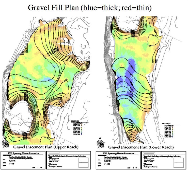
LMR 2003 Design 1B
The concept guiding 2003 site rehabilitation was to create slope to promote rehabilitation of downstream riffles, while at the same time maintaining the high quality of habitat at this location.Although there would be erosion risk at the downstream end of the project, the idea was the the 2004 project at the next riffle downstream would back water up to this site. That backwater effect would raise water levels and decrease velocities over the downstream end of the 2003 site, thereby protecting it.
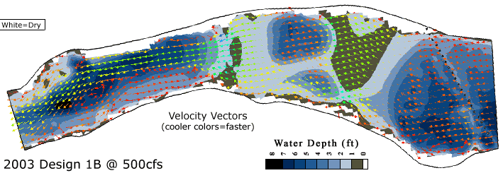
Design 1B involved raising the riffle crest by 3.0' and accentuating the pre-existing bar morphology to yield a large transverse bar. To protect the bar from low -flow scour due to the increased slope, the crest was notched to allow some flow to bypass it. Flow through the notch is passed over a longitudinal bar at an oblique angle and then over a secondary riffle. After that, a large slope break occurs where the channel returns to its pre-existing bed slope.
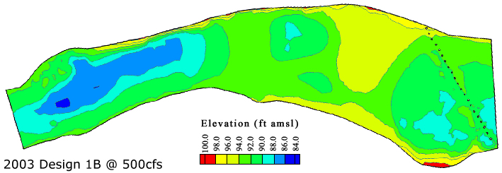
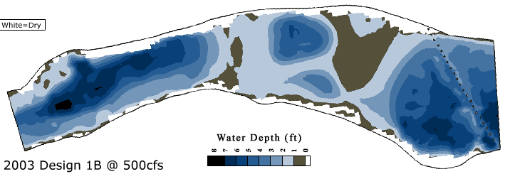
Predicted water depths show that raising the riffle elevation provides broad areas of shallow water habitat, but in accentuating the topography it also creates a deeper pool upstream of the riffle, which would have to be filled in the following year when more gravel is available.
Velocity magnitudes are predicted to range from 0- 10 ft/s, with the peak occurring over the riffle exit where the slope transitions between the new and pre-existing values. The notch is predicted to reduce velocities over the majority of the riffle crest to some extent. Flow through the pool is enhanced to occur within a narrow thalweg . These velocities were much higher than desired.
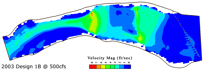
Most of the flow goes straight over the riffle crest, with a small amount converging into the notch. After passing through the notch, some flow diverts left and some diverts cross-channel over the central bar and into the smaller pool. Flow then goes over the downstream riffle and converges into the downstream pool. A moderate secondary flow cell occurs in the pool on river left constricting the thalweg .
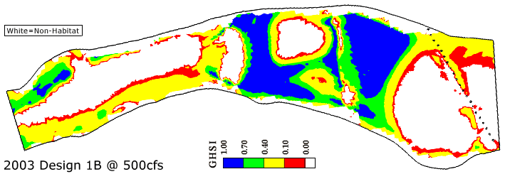
This design is predicted to yield a trade-off in habitat quality. On one hand, riffle habitat is broadly improved to good quality for spawning. On the other hand, bed topography accentuation has turned large areas of low quality spawning habitat into larger pools for adult holding habitat.
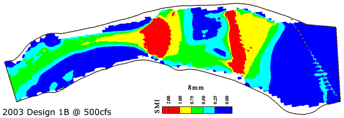
8 mm gravels were predicted to be highly susceptible to scour over the two flat riffle areas at t his discharge, due to the lack of a downstream riffle with sufficient elevation to back water up to manage flow velocity.
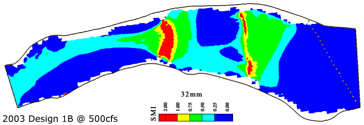
32 mm gravels were predicted to be susceptible to scour over the riffle crest and riffle exit at this discharge.
64 mm cobbles were predicted to be susceptible to scour over small portions of the riffle crest and portions of the riffle exit at this discharge.
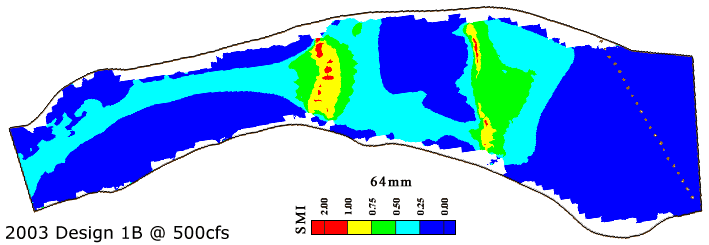
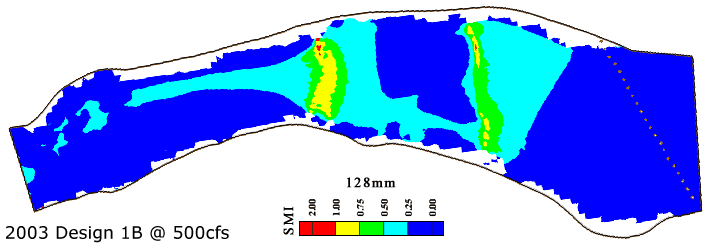
Even 128 mm cobbles were predicted to be susceptible to scour over local perturbations on the riffle crest and over the riff le exit at this discharge.
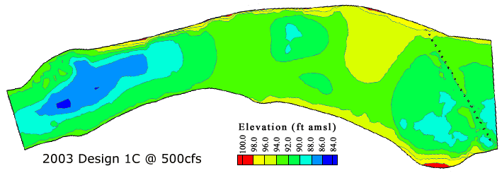
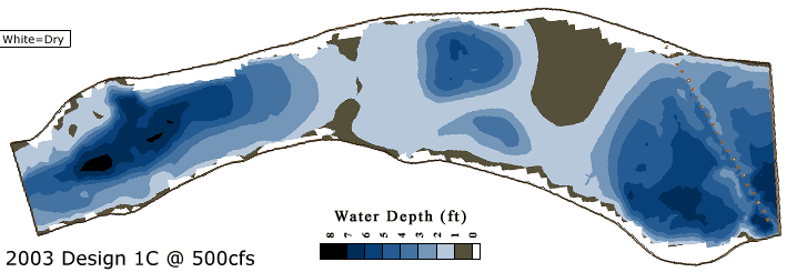
LMR 2003 Design 1C
The concept guiding 2003 site rehabilitation was to create slope to promote rehabilitation of downstream riffles, while at the same time maintaining the high quality of habitat at this location. Although there would be erosion risk at the downstream end of the project, the idea was the the 2004 project at the next riffle downstream would back water up to this site. That backwater effect would raise water levels and decrease velocities over the downstream end of the 2003 site, thereby protecting it.
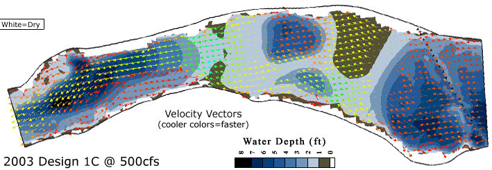
Design 1C was a modification of 1B in which the notch was widened to see if lateral flow bypass ing could be used to reduce velocities and scour risk over 1B. Flow through the notch is passed over a longitudinal bar at an oblique angle and then over a secondary riffle. After that , a large slope break occurs where the channel returns to its pre -exist ing bed slope.
Predicted water depths show that widening the notch does decrease riffle crest depth and depth over the downstream broad, flat riffle area.
Predicted velocity magnitudes show that the wider notch does reduce velocities over the crest, but velocities are still significantly higher than ultimately desired. Velocities over the riffle exit are spread over a wider region, as the wider notch distributed more flow to the river left area.
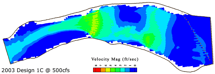
Part of the flow diverges slightly over the riffle crest and a lot converges into the notch. After passing through the notch, flow splits and some continues straight while some diverts cross-channel over the central bar and into the smaller pool. Flow then goes over the downstream riffle and converges into the downstream pool. A moderate secondary flow cell occurs in the pool on river left constricting the thalweg .
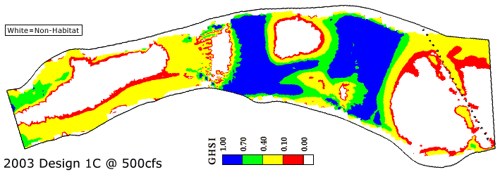
Relative to Design 1B, Design lC has better quality habitat over the riffle crest due to the effectiveness of the notch. However, the riffle exit is still too fast to serve as spawning habitat and the upstream pool is very large.
Although the area of scour of 8 mm gravels is reduced over the riffle crest by employ ing a wider notch, this is offset by a larger region of scour on the downstream broad, flat riffle area and over the riffle exit.
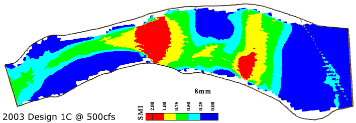
Scour of 32 mm gravels is predicted to occur over the riffle exit. Overall, the amount of scour is significantly reduced at this discharge relative to Design 1B.
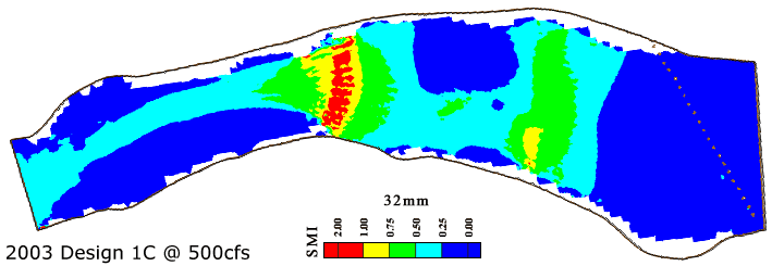
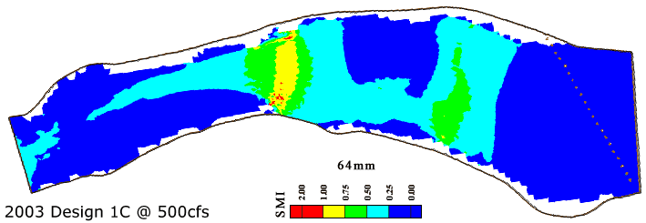
64 mm cobbles are predicted to be subjected to intermittent scour where infrequent, strong turbulent bursts could yield forces exceeding the average predicted conditions over the riffle exit at this discharge. The rest of the site is not predicted to have its 64 mm cobbles scour, which is a significant improvement due to the wider notch.
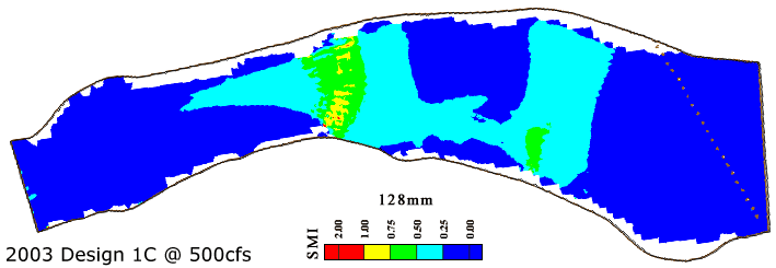
128 mm cobbles are predicted to be subjected to intermittent scour where infrequent, strong turbulent bursts could yield forces exceeding the average predicted conditions over local perturbations over the riffle exit at this discharge. The rest of the site is not predicted to have its 128 mm cobbles scour, which is a significant improvement due to the wider notch.
LMR 2003 Design 1D
The concept guiding 2003 site rehabilitation was to create slope to promote rehabilitation of downstream riffles, while at the same time maintaining the high quality of habitat at this location. Although there would be erosion risk at the downstream end of the project, the idea was the the 2004 project at the next riffle downstream would back water up to this site. That backwater effect would raise water levels and decrease velocities over the downstream end of the 2003 site, thereby protecting it.
Design 1D was a modification of 1C in which the crest elevation was dropped by 1.5' and that gravel was used to make the upstream pool smaller and the riffle exit slope more gradual. These changes were attempted to further reduce velocities and scour risk over 1C. Flow through the notch is passed over a longitudinal bar at an oblique angle and t hen over a secondary riffle. After that, a slope break occurs where the channel returns to its pre-existing bed slope.
Predicted water depths show that the riffle crest depth remains 0-1' and now a much larger area of 1-2' deep occurs over the downstream broad, flat riffle area.
Predicted velocity magnitudes are now 0-7 ft/s. Velocities over the riffle crest are now the desirable 2-3 ft/s, except over the notch where they reach 5 ft/s. Velocities over the riffle exit are spread over a wide region and are mostly 5-6 ft/s. While this is still higher than desired, it is designed to be solved in 2004 by building up the downstream riffle and thereby shift ing the usable energy from this location to a riffle needing it downstream.
Part of the flow diverges over the riffle crest and part converges into the notch. After passing through the notch, flow diverts cross-channel over the central bar and into the smaller pool. Flow then diverges over the downstream riffle before converging into the downstream pool. A secondary flow cell occurs in the pool on river left and partially constricts the thalweg.
Relative to Designs 1B and 1C, Design 1D has better quality habitat over the riffle crest and more habitat over a longer downstream broad, flat riffle area. The upstream pool is significantly reduced in size over earlier designs, but is still larger than the pre-existing case, necessitating gravel inject ion in 2004. The riffle exit is still too fast to serve as spawning habitat, but this is planned to be resolved by adding gravel downstream in 2004 to back water up and reduce the local slope at this location.
The area of scour of 8 mm gravels is reduced over the riffle crest and riffle exit, but it is still significant at this spawning discharge. This is only intended to be the case for 1 year until gravel is added downstream.
32 mm gravels were predicted to be subjected to intermittent scour where infrequent, strong turbulent bursts could yield forces exceeding the average predicted conditions over the riffle exit at t his discharge . The rest of the site is not predicted to have its 32 mm gravels scour, which is a significant improvement over designs 1B and 1C.
64 and 128 mm sized cobbles were predicted to be unlikely to scour anywhere on-site at this discharge.
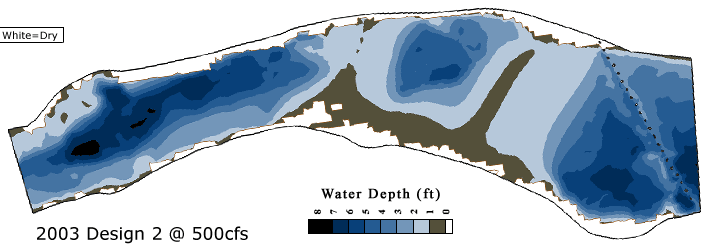
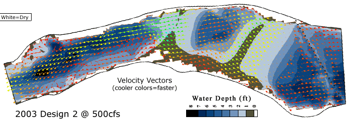
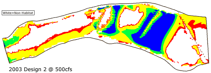
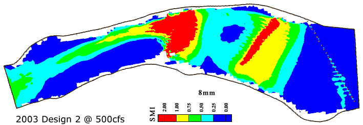
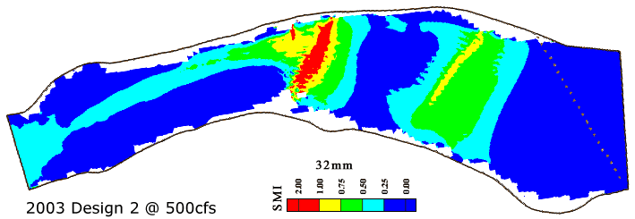
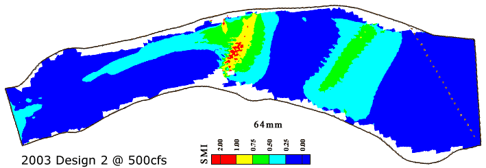
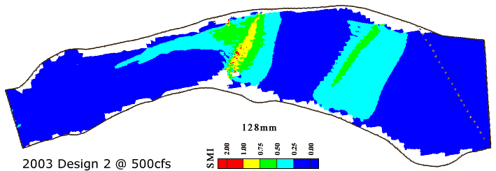
LMR 2003 Design 2
The concept guid ing 2003 site rehabilitation was to create slope to promote rehabilitation of downstream riffles, while at the same time maintaining the high quality of habitat at this location. Although there would be erosion risk at the downstream end of the project, the idea was the the 2004 project at the next riffle downstream would back water up to this site. That backwater effect would raise water levels and decrease velocities over the downstream end of the 2003 site, thereby protecting it.
Design 2 involved increasing the riffle crest by 1.5' and using gravel build a larger river - left point bar with two large transverse bars providing riffle habitat. A slope break occurs at the end of the project where the gravel addition ends and the channel returns to its pre-existing bed slope.
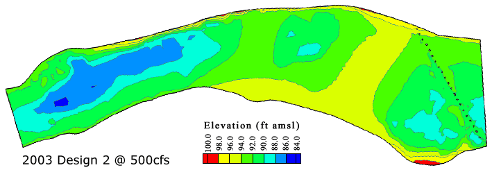
Predicted water depths show that the riffle crest depth includes a zone of 0-1' and a front-slope area with depth 1-2'. The point bar is partially exposed at this high spawning flow, which is not desirable.
Predicted velocities range from 0-8 ft/s. The primary riffle crest has mostly 3-4 ft/s, which is a little higher than desired. The second riffle has velocities of 5-8 ft/s due to the slope break. The main thalweg through the pool is highly concentrated .
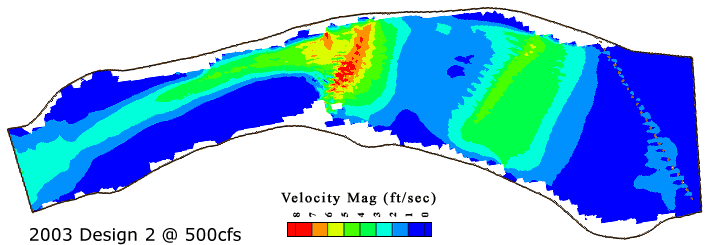
Flow passes uniformly over the riffle crest and then converges in the small pool. The constriction provided by the point bar and the second transverse bar forces a strong thalweg constrict ion exacerbating high velocities at the riffle exit . A strong secondary flow cell occurs in the downstream pool constrict ing the thalweg.
Spawning habitat was predicted to be good quality over the riffle entrance and part of the riffle crest. Part of the secondary transverse bar is good habitat, but velocities are mostly too fast to yield good habitat there.
8 mm gravels were predicted to scour over the riffle crest, downstream riffle, and riffle exit, at this discharge.
32 mm gravels were predicted to scour over the riffle exit at this discharge.
64 and 128 mm sized cobbles were predicted to scour over a few local perturbations at the riffle 0.50 exit at this discharge.
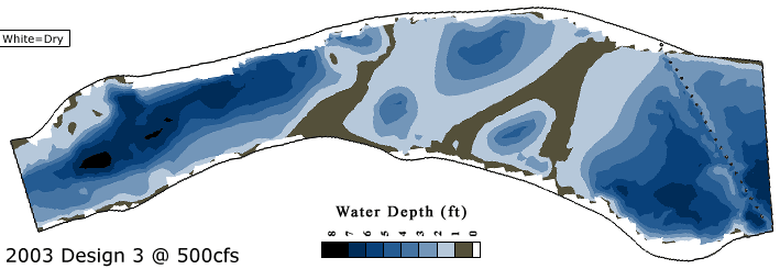
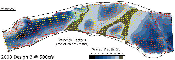
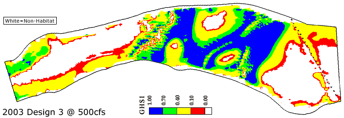
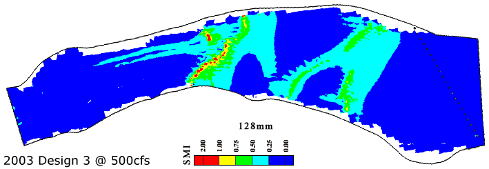
LMR 2003 Design 3
The concept guiding 2003 site rehabilitation was to create slope to promote rehabilitation of downstream riffles, while at the same time maintaining the high quality of habitat at this location. Design 3 involved increasing the riffle crest by 1.5' and creating a complex bed with high depth diversity to serve a wider variety of spawning discharges and to yield spatial habitat diversity. Although there would be erosion risk at the downstream end of the project, the idea was the the 2004 project at the next riffle downstream would back water up to this site. That backwater effect would raise water levels and decrease velocities over the downstream end of the 2003 site, thereby protecting it.
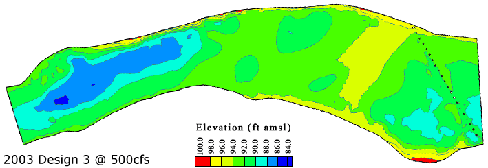
Water depths over the gravel addition area range from 0-5 '. The riffle crest has depths of 0- 1' and there are substantial areas of 1-2' depth, as desired.
Velocities over the gravel addition area were predicted to range from 0-5 ft/s, except for the riffle exit where the transition to the pre-existing slope causes high flow acceleration.
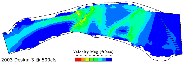
The complex flow pattern in t his design involves flow divergence over riffles and flow convergence over pools. The riffle exit is oblique to the channel, so that yields a highly convergent flow pattern, which contributes to high velocities over the riffle exit and pushed flow strongly to the river right. A weak secondary flow cell occurs over the left side of the downstream pool.
Good quality spawning habitat was widely distributed throughout the project area. Local areas of high velocity or high depth were not usable habitat, but the high diversity of habitat types was considered a strong feature of this design.
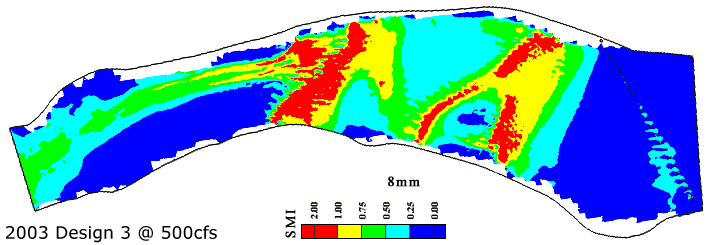
Widespread scour of 8 mm gravels was predicted for this design at this discharge.
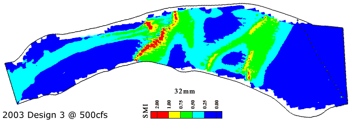
32 mm gravels were predicted to scour over the riffle exit at this discharge.
64 mm cobbles were predicted to be susceptible to scour over portions of the riffle exit.
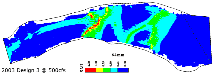
128 mm cobbles were predicted to be susceptible to scour over highly localized portions of the riffle exit.
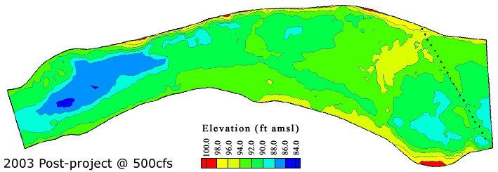
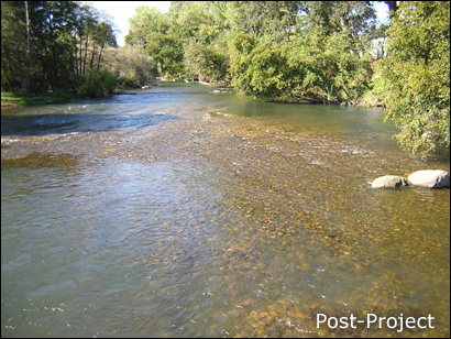
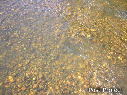
LMR 2003 As-Built
The post-project as-built condition was based on Design 1D, with a crest height increase of ~1.5' and a wide notch. Boulders were not included in the design process this time due to time constraints, but were located in clusters based on past experience using them in 1999-2002. As a result of construction uncertainty, the central bar ended up wider than desired. Although there would be erosion risk at the downstream end of the project, the idea was the the 2004 project at the next riffle downstream would back water up to this site. That backwater effect would raise water levels and decrease velocities over the downstream end of the 2003 site, thereby protecting it.
LMR 2003 Site Photos
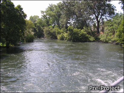
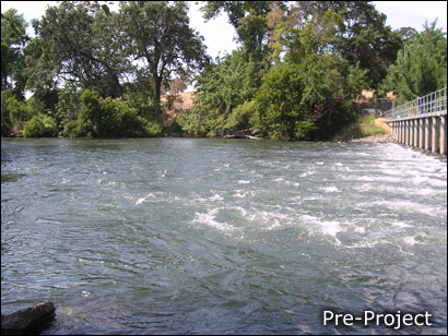
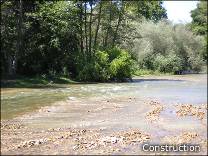
LMR 2003 Pre-Project Photos
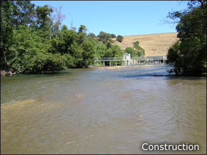
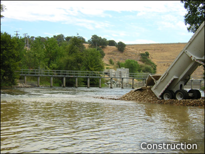
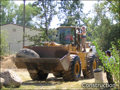
LMR 2003 Construction Photos
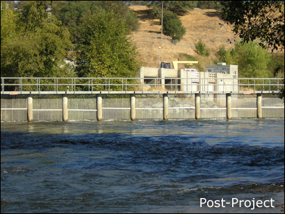
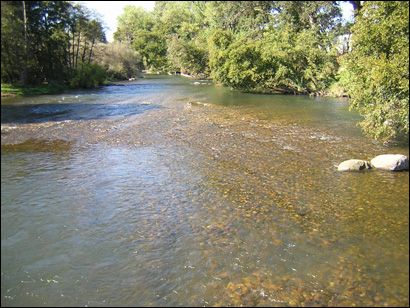
LMR 2003 As-Built Photos
LMR 2003 Site Movies
Front loader placing gravel and cobble into the river.
Front loader placing a large boulder at the designated location.
Truck that brings gravel and cobble from the nearby quarry. This video is sped up by 2x.