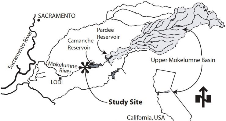
LMR Site Description
LMR Problem Identification
- A scientific and political consensus reached for the LMR has concluded that in-river spawning habitat is an important constraint on the river's salmonid populations (FERC, 1993; USFWS, 1997; Merz, 2004).
- The overall goal of EBMUD's river rehabilitation program has been to replenish suitable-sized coarse sediment in the spawning reach of the LMR and to provide immediate high-quanlity spawning habitat for Chinook salmon and steelhead trout- recognizing that placed gravels would not remain static over time.
LMR SHIRA Goals
- Characterize the existing fluvial geomorphology, in-stream hydrodynamics, and spawning habitat at each rehabilitation project site below Camanche Dam.
- Develop multiple alternative designs and recommend a final design for each rehabilitation project.
- Predict and evaluate physical habitat and associated redd locations for existing and post-construction channel conditions for each rehabilitation project.
- Recommend adaptive management strategies for future gravel addition projects.
LMR Pre-Dam Conditions
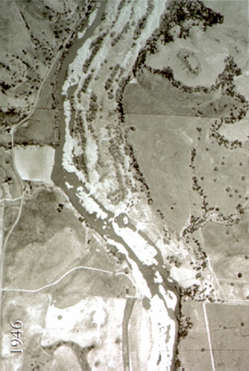
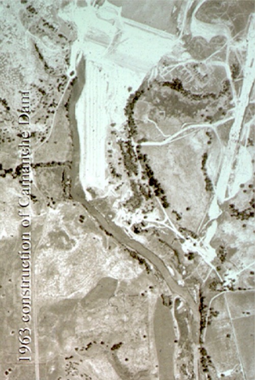
A really good historical analysis of the LMR was performed by Edwards (2002). The historical aerial photos below show the contrast of the river before and after the river was dammed, channelized, and a hatchery was built over a large portion of the former active floodway. A key outcome of the re-engineering of the river below the dam was that the river essentially became a ditch forced up against a valley wall on its river-right flank with nowhere to spread and no way to meander or anastomose.
- Edwards, B.R. (2001). Vegetation of the Lower Mokelumne River: 1927, Advanced Spatial Analysis Facility, Humboldt State University, Arcata, CA.
LMR 1946
LMR 1963
LMR SHIRA Location Map
LMR Hydrology
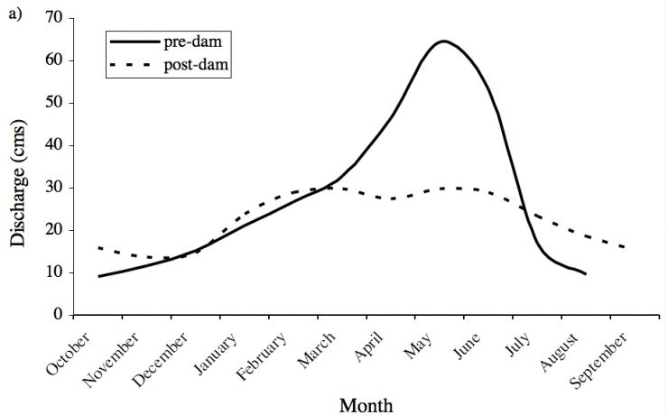
Prior to Camanche Dam, annual peak flows 1904-1963 were > 200 cumecs 21 of 57 years. Since 1964, releases are capped <142 cumecs. Pre-dam, the annual hydrograph was snowmelt-dominated, with highest flow May-June well after peak precipitation. Post-dam, snowmelt runoff was greatly reduced. Flood frequency analysis revealed a dramatic reduction in flow magnitude for all recurrence intervals (Pasternack et al. 2004). Since May 2000, flow has been near the 4.25 cumecs minimum prescribed In re- licensing (FERC, 1998).
LMR Fish Biology
The LMR supports > 35 fish species, including 5 anadromous species: fall-run Chinook salmon, winter steelhead trout, American shad, striped bass and Pacific lamprey (Merz, 2004). Native Chinook salmon and steelhead trout populations are enhanced by hatchery fish produced at Camanche Dam. Prior to Camanche, spawning areas accommodated ~ 40,000 adults at 400 cfs (CDFG 1955). Post-Camanche Dam, Chinook salmon runs have averaged ~ 3,800 spawners. USFWS (1997) called for a LMR fall -run Chinook salmon population target of 9,300. Average annual LMR salmon escapement has been monitored by video at Woodbridge Dam 1990-2004. Chinook escapement averages 5506 (min:280; max:10757). Steelhead escapement is < 100 (Workman, 2003). Most spawning occurs in the 15 km between Camanche and Elliott Rd.
LMR SHIRA Constraints
Gravel quantity
- ~2000-4000 tons triple-washed coarse sediment per yr
Budget
- ~$80,000 per year for SHIRA implementation.
- Gravel/cobble purchase cost and site construction cost covered by EBMUD, including any grants they get
Construction access
- Easy access to river left bank through Mokelumne River Day Use Area.
Construction timing
- August or early September.
Potential negative project impacts
- None.
LMR SHIRA Timeline
LMR SHIRA Hydraulic-Unit Scientific Question
At the hydraulic-unit scale there is little geomorphic research to guide design in gravel bed rivers. Thus, how do different local lateral and slope adjustments affect local hydraulics, sediment transport, and channel morphology? What are the options and potential benefits of different hydraulic-unit scale designs?
LMR SHIRA Geomorphic-Unit Scientific Question
At the geomorphic-unit scale, how do we go about re-building a regulated river's entire longitudinal profile form the dam on downstream, including alternating riffle-pool units?
LMR SHIRA Reach-Scale Scientific Question
After SHIRA projects are built, can floods re-distribute placed gravel/cobble down the river retaining coherent geomorphic and hydraulic units?