Geomorphic Unit Scale
Geomorphic Unit?
What Is A Geomorphic Unit?
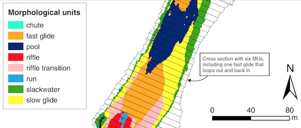
A river channel is a complex configuration of morphologies, ranging from the dendritic drainage networks at the catchment scale to cobble clusters at the centimeter scale. Scientists have long recognized landforms with distinct local form–process associations at ~ 1–10 channel widths scale that may be the fundamental building blocks describing the geomorphic structure of a river. These landforms go by various synonymous names, including geomorphic unit, morphological unit, and channel unit. The last of these only suffers for its constraint in the channel, whereas a geomorphic unit or morphological unit can occur any where. The choice to use geomorphic unit or morphological unit is merely semantic and subjective, with the choice varying regionally around the world.

For more information on landforms at this scale, see this research by Wyrick and Pasternack.
Geomorphic Unit SHR

- Prior to SHIRA, the practice for geomorphic unit rehabilitation involved mimicking the channel geometry of the geomorphic units in reference reaches of perceived healthier rivers. This practice still goes on today, though it has been largely discredited for lack of scientific merit.
- There is extensive evidence that mimicry of riverine landforms and mimicry of flow regimes both fail to yield natural physical processes, because the devil is in the details. It is not enough to match a physical process or ecosystem concept- one has to get the correct local conditions to really turn on that dynamism and this is where most projects fail, because they lacked sufficient design and design evaluation expenditure to do this essential step.
- We hypothesized at the outset that designing to achieve essential physical processes and ecological functions would be superior to just mimicking forms or flows.
- The approach to insuring that processes and functions are present involves mechanistic, predictive numerical modeling, and almost 20 years of this effort have proven that our ideas are correct. You can use models to predict project outcomes, and thus you can design projects to have processes, not just mimic forms and flow patterns.
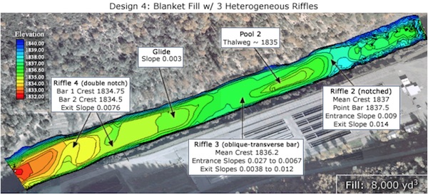
- The example image on this page shows one of the design concepts for Geomorphic Unit Scale SHR on the Trinity River below Lewiston Dam. the design includes coherent, organized geomorphic units with a diversity of smaller scale hydraulics units. A transparent purpose was documented for each geomorphic unit as well as their sequencing.
Cautionary Tales
- Geomorphic Units are often designed using prescriptive empirical geomorphology. In other words, design based on mimicking the forms observed in other rivers.
- Although there do exist regional similarities in how rivers organize their landforms and this central tendency can be captured by simple regression analysis, the actual geomorphic processes and ecological functions associated with geomorphic units depend on local variability that is not captured by these prescriptive empirical functions. In other words, the devil is in the details!
- It does appear now that there may exist proper statistical functions to explain and control geomorphic processes that depend on topographic variability, and these are called Geomorphic Covariance Structures. However this theory is too new to have penetrated common practice yet.
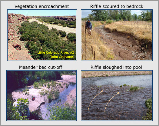
- The graphic below shows four examples of project failures common when geomorphic units are designed only using prescriptive empirical geomorphology.
- Prescriptive empirical geomorphology fails for many reasons, such as (i) it assumes channels are uniform when they are not, (ii) it applies science developed for temperate climates to other climates where the ideas are incorrect or different, (iii) it emphasizes central tendency over variability even though geomorphic processes are primarily controlled by variability, (iv) it misses the importance of the transitions between geomorphic units. Many other problems exist and have been explained in many journal articles over the last 25 years.

Geomorphic Process Testing
- With or without empirical, statistical design tools, one should always test designs for their geomorphic processes and ecological functions to the extet feasible.
- Geomorphologists, ecohydraulicists, and ecologists have developed many tools for testing designs, so there is ample opportunity to do this.
- The textbook, 2D Modeling and Ecohydraulic Analysis, presents a set of such methods. Many others exist.
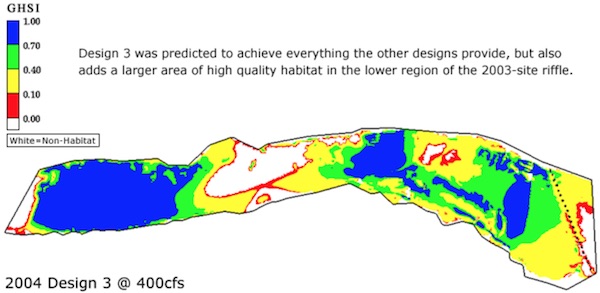
- The image below shows an example of design testing. This map illustrates a prediction of the pattern of adult Chinook salmon spawning habitat quality expected at a specified discharge if a particular design is built.

